Jefferson Heights elevation
Jefferson Heights (New York, Greene County), United States elevation is 56 meters and Jefferson Heights elevation in feet is 184 ft above sea level [src 1]. Jefferson Heights is a populated place (feature code) with elevation that is 223 meters (732 ft) smaller than average city elevation in United States.
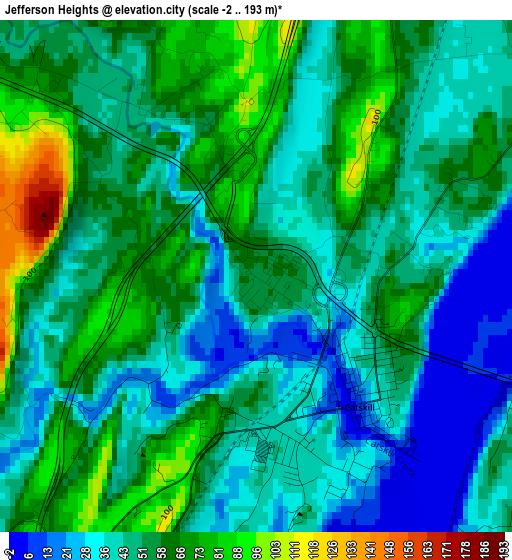
Below is the Elevation map of Jefferson Heights, which displays elevation range with different colors. Scale of the first map is from -2 to 193 m (-7 to 633 ft) with average elevation of 50.6 meters (=166 ft) [note 1]
These maps also provides idea of topography and contour of this city, they are displayed at different zoom levels. More info about maps, scale and edge coordinates you can find below images.
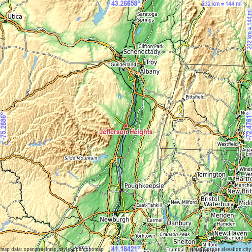
| \ | Map #1 | Topo.Map |
| Scale [m] | -2..193 m | × |
| Scale [ft] | -7..633 ft | × |
| Average | 50.6 m = 166 ft | × |
| Width | 7.24 km = 4.5 mi | 231.5 km = 143.8 mi |
| Height | 7.24 km = 4.5 mi | 231.5 km = 143.8 mi |
| ↑Max Latitude | 42.266509° | 43.26658° |
| Latitude at center | 42.23398° | 42.23398° |
| ↓Min Latitude | 42.201434° | 41.18421° |
| ← Min Longitude | -73.926295° | -75.2886° |
| Longitude center | -73.88235° | -73.88235° |
| →Max Longitude | -73.838405° | -72.4761° |
Nearby cities:
Cities around Jefferson Heights sort by population:
• Oakdale elevation 38 m
8.6 km,  77°
77°
• Hudson 27 m
7.8 km,  74°
74°
• Saugerties 48 m
18.3 km,  198°
198°
• Catskill 17 m
2.4 km,  141°
141°
• Coxsackie 44 m
14.6 km,  26°
26°
• Lorenz Park 56 m
9.9 km, 70°
• Athens 7 m
6.7 km,  63°
63°
• Cairo 118 m
12 km,  307°
307°
• Stottville 35 m
13.2 km, 63°
• Philmont 127 m
18.9 km,  85°
85°
• Tivoli 47 m
19.6 km,  186°
186°
• Palenville 172 m
13.1 km,  239°
239°
Multilingual:
 En español:
Jefferson Heights elevación 56 m.
 En France:
Jefferson Heights élévation 56 m.
 Auf Deutsch:
Jefferson Heights höhe über dem Meeresspiegel ist 56 m.

Sources and notes:
- [note 1] Map square and city borders are not equal. Map elevation data is calculated only from area inside that square.
- [src 1] Elevation data from geonames database provided with same terms of usage.
- [src 2] The elevation map of Jefferson Heights is generated using elevation data from NASA's 3 arcsec (90m) resolution SRTM data.
- [src 3] Base (background) map © OpenStreetMap contributors tiles are generated by Geofabrik and OpenTopoMap.
Copyright & License:
This Jefferson Heights Elevation Map is licensed under CC BY-SA. You may reuse any part from this page, if you give a proper credit by linking to this URL:
 More info on terms of use page.