Holley elevation
Holley (New York, Orleans County), United States elevation is 167 meters and Holley elevation in feet is 548 ft above sea level [src 1]. Holley is a populated place (feature code) with elevation that is 112 meters (367 ft) smaller than average city elevation in United States.
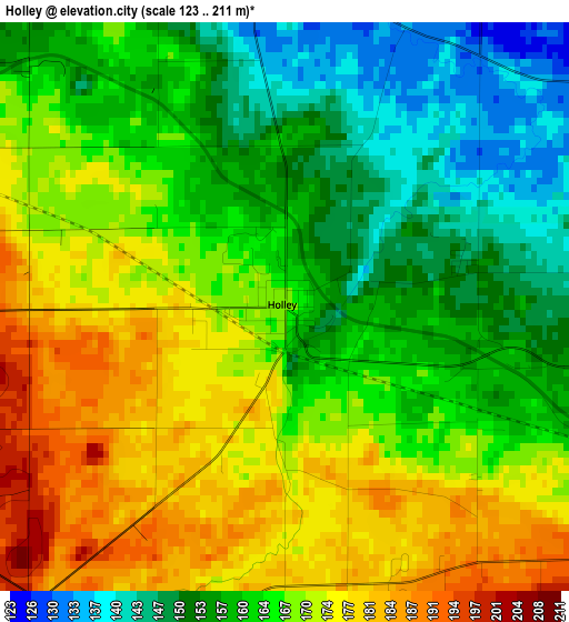
Below is the Elevation map of Holley, which displays elevation range with different colors. Scale of the first map is from 123 to 211 m (404 to 692 ft) with average elevation of 165 meters (=541 ft) [note 1]
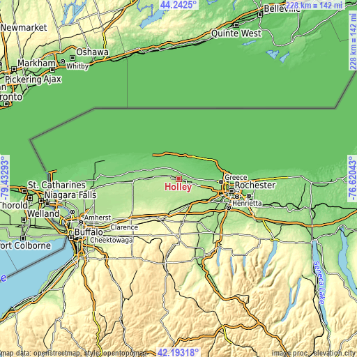
These maps also provides idea of topography and contour of this city, they are displayed at different zoom levels. More info about maps, scale and edge coordinates you can find below images.
| \ | Map #1 | Topo.Map |
| Scale [m] | 123..211 m | × |
| Scale [ft] | 404..692 ft | × |
| Average | 165 m = 541 ft | × |
| Width | 7.12 km = 4.4 mi | 227.9 km = 141.6 mi |
| Height | 7.12 km = 4.4 mi | 227.9 km = 141.6 mi |
| ↑Max Latitude | 43.258462° | 44.2425° |
| Latitude at center | 43.22645° | 43.22645° |
| ↓Min Latitude | 43.194421° | 42.19318° |
| ← Min Longitude | -78.070625° | -79.43293° |
| Longitude center | -78.02668° | -78.02668° |
| →Max Longitude | -77.982735° | -76.62043° |
Nearby cities:
Cities around Holley sort by population:
• Gates-North Gates elevation 170 m
27.3 km,  104°
104°
• Greece 134 m
27.1 km,  93°
93°
• North Gates 163 m
26.9 km, 101°
• Brockport 162 m
7.2 km, 101°
• Albion 166 m
13.7 km,  279°
279°
• Hilton 87 m
20.1 km,  70°
70°
• Hamlin 98 m
12.1 km,  45°
45°
• Clarkson 130 m
8.1 km,  84°
84°
• Spencerport 172 m
18.6 km, 103°
• Churchville 179 m
17.8 km,  139°
139°
• Oakfield 232 m
26.6 km,  227°
227°
• Bergen 187 m
17.1 km,  156°
156°
Multilingual:
 En español:
Holley elevación 167 m.
 En France:
Holley élévation 167 m.


Sources and notes:
- [note 1] Map square and city borders are not equal. Map elevation data is calculated only from area inside that square.
- [src 1] Elevation data from geonames database provided with same terms of usage.
- [src 2] The elevation map of Holley is generated using elevation data from NASA's 3 arcsec (90m) resolution SRTM data.
- [src 3] Base (background) map © OpenStreetMap contributors tiles are generated by Geofabrik and OpenTopoMap.
Copyright & License:
This Holley Elevation Map is licensed under CC BY-SA. You may reuse any part from this page, if you give a proper credit by linking to this URL:
 More info on terms of use page.