Highland Mills elevation
Highland Mills (New York, Orange County), United States elevation is 159 meters and Highland Mills elevation in feet is 522 ft above sea level [src 1]. Highland Mills is a populated place (feature code) with elevation that is 120 meters (394 ft) smaller than average city elevation in United States.
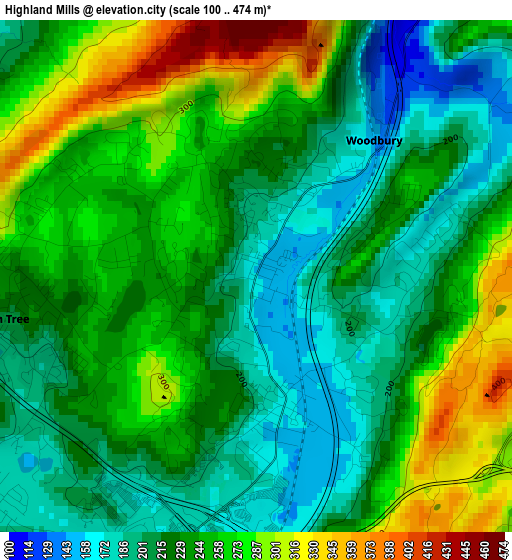
Below is the Elevation map of Highland Mills, which displays elevation range with different colors. Scale of the first map is from 100 to 474 m (328 to 1555 ft) with average elevation of 236.7 meters (=777 ft) [note 1]
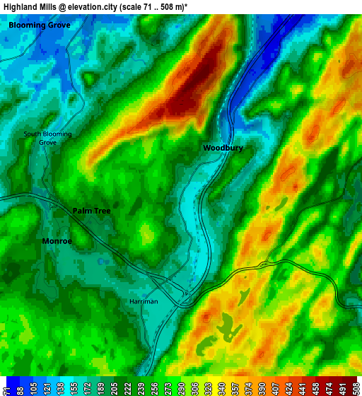
These maps also provides idea of topography and contour of this city, they are displayed at different zoom levels. More info about maps, scale and edge coordinates you can find below images.
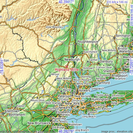
| \ | Map #1 | Map #2 | Topo.Map |
| Scale [m] | 100..474 m | 71..508 m | × |
| Scale [ft] | 328..1555 ft | 233..1667 ft | × |
| Average | 236.7 m = 777 ft | 243.6 m = 799 ft | × |
| Width | 7.34 km = 4.6 mi | 14.67 km = 9.1 mi | 234.8 km = 145.9 mi |
| Height | 7.34 km = 4.6 mi | 14.67 km = 9.1 mi | 234.8 km = 145.9 mi |
| ↑Max Latitude | 41.380022° | 41.412988° | 42.39417° |
| Latitude at center | 41.34704° | 41.34704° | 41.34704° |
| ↓Min Latitude | 41.314041° | 41.281025° | 40.28279° |
| ← Min Longitude | -74.170205° | -74.214151° | -75.53251° |
| Longitude center | -74.12626° | -74.12626° | -74.12626° |
| →Max Longitude | -74.082315° | -74.038369° | -72.72001° |
Nearby cities:
Cities around Highland Mills sort by population:
• Kiryas Joel elevation 210 m
3.5 km,  260°
260°
• Woodbury 146 m
2.6 km,  41°
41°
• Monroe 199 m
5.4 km,  250°
250°
• Washingtonville 98 m
9.6 km,  339°
339°
• South Blooming Grove 172 m
5.2 km,  303°
303°
• Walton Park 262 m
9.5 km,  244°
244°
• Harriman 167 m
4.6 km,  199°
199°
• Beaver Dam Lake 121 m
11.2 km,  4°
4°
• Beaverdam Lake-Salisbury Mills 104 m
10.5 km, 4°
• Central Valley 162 m
1.8 km,  165°
165°
• Mountain Lodge Park 248 m
4.8 km, 344°
• Fort Montgomery 55 m
11.8 km,  98°
98°
Multilingual:
 En español:
Highland Mills elevación 159 m.
 En France:
Highland Mills élévation 159 m.
 Auf Deutsch:
Highland Mills höhe über dem Meeresspiegel ist 159 m.

Sources and notes:
- [note 1] Map square and city borders are not equal. Map elevation data is calculated only from area inside that square.
- [src 1] Elevation data from geonames database provided with same terms of usage.
- [src 2] The elevation map of Highland Mills is generated using elevation data from NASA's 3 arcsec (90m) resolution SRTM data.
- [src 3] Base (background) map © OpenStreetMap contributors tiles are generated by Geofabrik and OpenTopoMap.
Copyright & License:
This Highland Mills Elevation Map is licensed under CC BY-SA. You may reuse any part from this page, if you give a proper credit by linking to this URL:
 More info on terms of use page.