Hannawa Falls elevation
Hannawa Falls (New York, St. Lawrence County), United States elevation is 174 meters and Hannawa Falls elevation in feet is 571 ft above sea level [src 1]. Hannawa Falls is a populated place (feature code) with elevation that is 105 meters (344 ft) smaller than average city elevation in United States.
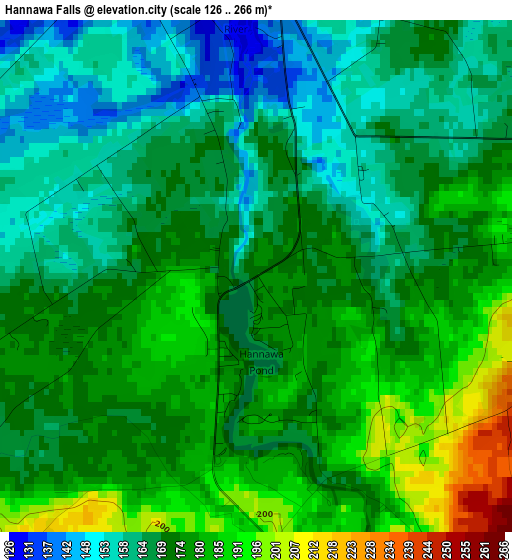
Below is the Elevation map of Hannawa Falls, which displays elevation range with different colors. Scale of the first map is from 126 to 266 m (413 to 873 ft) with average elevation of 171.9 meters (=564 ft) [note 1]
These maps also provides idea of topography and contour of this city, they are displayed at different zoom levels. More info about maps, scale and edge coordinates you can find below images.
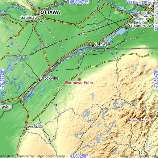
| \ | Map #1 | Topo.Map |
| Scale [m] | 126..266 m | × |
| Scale [ft] | 413..873 ft | × |
| Average | 171.9 m = 564 ft | × |
| Width | 6.96 km = 4.3 mi | 222.6 km = 138.3 mi |
| Height | 6.96 km = 4.3 mi | 222.6 km = 138.3 mi |
| ↑Max Latitude | 44.643555° | 45.60473° |
| Latitude at center | 44.61228° | 44.61228° |
| ↓Min Latitude | 44.580988° | 43.60258° |
| ← Min Longitude | -75.014975° | -76.37728° |
| Longitude center | -74.97103° | -74.97103° |
| →Max Longitude | -74.927085° | -73.56478° |
Nearby cities:
Cities around Hannawa Falls sort by population:
• Ogdensburg elevation 91 m
41.8 km,  282°
282°
• Massena 68 m
35.7 km,  10°
10°
• Potsdam 132 m
6.4 km,  352°
352°
• Canton 113 m
15.8 km,  263°
263°
• Malone 215 m
59.5 km,  63°
63°
• Saranac Lake 469 m
73.7 km,  115°
115°
• Gouverneur 138 m
49.6 km,  231°
231°
• Tupper Lake 486 m
59 km,  137°
137°
• Norwood 101 m
15.6 km, 353°
• Norfolk 78 m
21 km,  355°
355°
• Fort Covington Hamlet 51 m
54.2 km,  42°
42°
• Philadelphia 150 m
77.6 km, 229°
Multilingual:
 En español:
Hannawa Falls elevación 174 m.
 En France:
Hannawa Falls élévation 174 m.
 Auf Deutsch:
Hannawa Falls höhe über dem Meeresspiegel ist 174 m.

Sources and notes:
- [note 1] Map square and city borders are not equal. Map elevation data is calculated only from area inside that square.
- [src 1] Elevation data from geonames database provided with same terms of usage.
- [src 2] The elevation map of Hannawa Falls is generated using elevation data from NASA's 3 arcsec (90m) resolution SRTM data.
- [src 3] Base (background) map © OpenStreetMap contributors tiles are generated by Geofabrik and OpenTopoMap.
Copyright & License:
This Hannawa Falls Elevation Map is licensed under CC BY-SA. You may reuse any part from this page, if you give a proper credit by linking to this URL:
 More info on terms of use page.