Greenlawn elevation
Greenlawn (New York, Suffolk County), United States elevation is 71 meters and Greenlawn elevation in feet is 233 ft above sea level [src 1]. Greenlawn is a populated place (feature code) with elevation that is 208 meters (682 ft) smaller than average city elevation in United States.
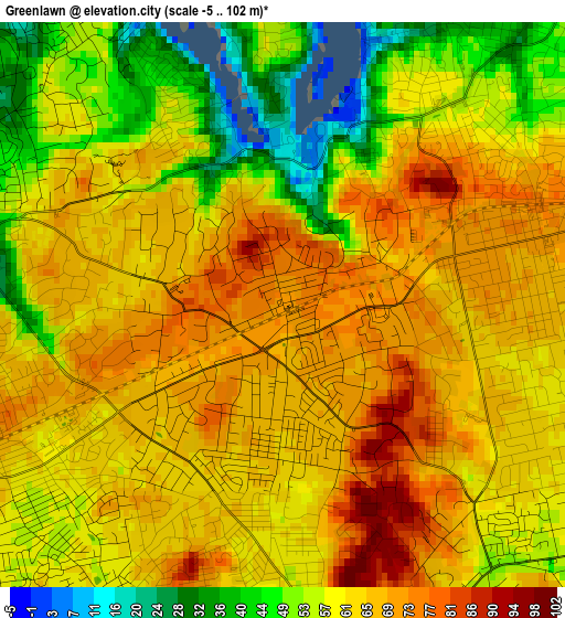
Below is the Elevation map of Greenlawn, which displays elevation range with different colors. Scale of the first map is from -5 to 102 m (-16 to 335 ft) with average elevation of 61.4 meters (=201 ft) [note 1]
These maps also provides idea of topography and contour of this city, they are displayed at different zoom levels. More info about maps, scale and edge coordinates you can find below images.
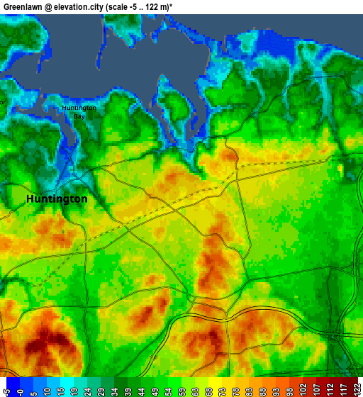
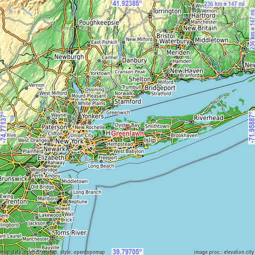
| \ | Map #1 | Map #2 | Topo.Map |
| Scale [m] | -5..102 m | -5..122 m | × |
| Scale [ft] | -16..335 ft | -16..400 ft | × |
| Average | 61.4 m = 201 ft | 54.8 m = 180 ft | × |
| Width | 7.39 km = 4.6 mi | 14.78 km = 9.2 mi | 236.5 km = 147 mi |
| Height | 7.39 km = 4.6 mi | 14.78 km = 9.2 mi | 236.5 km = 147 mi |
| ↑Max Latitude | 40.902213° | 40.93542° | 41.92385° |
| Latitude at center | 40.86899° | 40.86899° | 40.86899° |
| ↓Min Latitude | 40.83575° | 40.802493° | 39.79705° |
| ← Min Longitude | -73.409065° | -73.453011° | -74.77137° |
| Longitude center | -73.36512° | -73.36512° | -73.36512° |
| →Max Longitude | -73.321175° | -73.277229° | -71.95887° |
Nearby cities:
Cities around Greenlawn sort by population:
• Commack elevation 42 m
6.7 km,  115°
115°
• Huntington Station 66 m
4.3 km,  246°
246°
• Dix Hills 71 m
7.5 km,  161°
161°
• East Northport 70 m
3.5 km,  75°
75°
• Huntington 25 m
5.1 km,  268°
268°
• Elwood 61 m
3.6 km,  136°
136°
• Fort Salonga 11 m
7.3 km,  48°
48°
• South Huntington 66 m
5.8 km,  209°
209°
• Northport 24 m
4 km,  27°
27°
• Centerport 22 m
2 km,  332°
332°
• Halesite 18 m
4.7 km,  297°
297°
• Huntington Bay 16 m
5.4 km,  309°
309°
Multilingual:
 En español:
Greenlawn elevación 71 m.
 En France:
Greenlawn élévation 71 m.
 Auf Deutsch:
Greenlawn höhe über dem Meeresspiegel ist 71 m.

Sources and notes:
- [note 1] Map square and city borders are not equal. Map elevation data is calculated only from area inside that square.
- [src 1] Elevation data from geonames database provided with same terms of usage.
- [src 2] The elevation map of Greenlawn is generated using elevation data from NASA's 3 arcsec (90m) resolution SRTM data.
- [src 3] Base (background) map © OpenStreetMap contributors tiles are generated by Geofabrik and OpenTopoMap.
Copyright & License:
This Greenlawn Elevation Map is licensed under CC BY-SA. You may reuse any part from this page, if you give a proper credit by linking to this URL:
 More info on terms of use page.