Grand Island elevation
Grand Island (New York, Erie County), United States elevation is 178 meters and Grand Island elevation in feet is 584 ft above sea level [src 1]. Grand Island is a populated place (feature code) with elevation that is 101 meters (331 ft) smaller than average city elevation in United States.
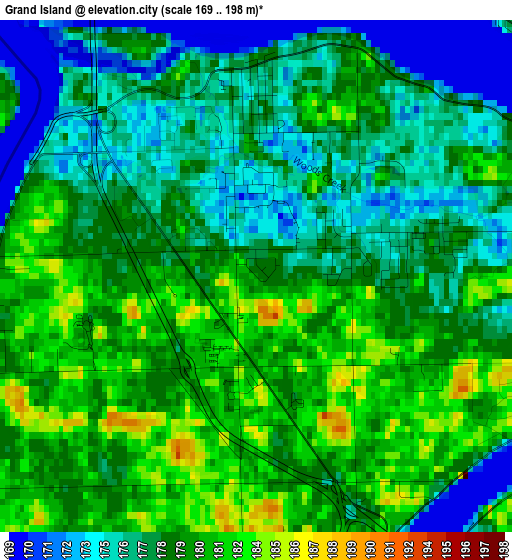
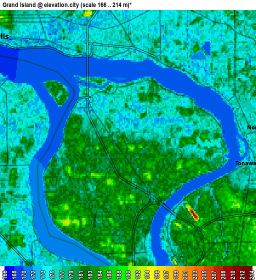
Below is the Elevation map of Grand Island, which displays elevation range with different colors. Scale of the first map is from 169 to 198 m (554 to 650 ft) with average elevation of 178.3 meters (=585 ft) [note 1]
These maps also provides idea of topography and contour of this city, they are displayed at different zoom levels. More info about maps, scale and edge coordinates you can find below images.
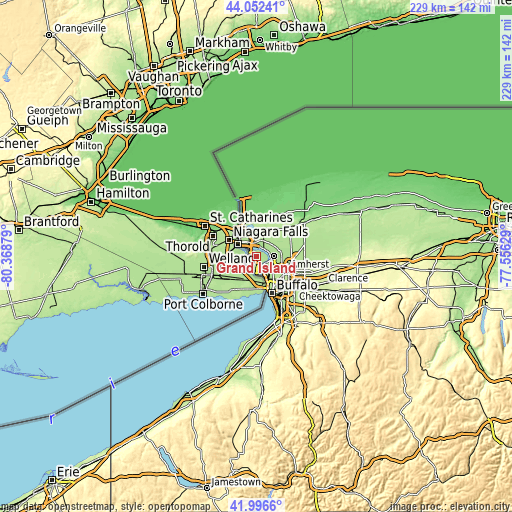
| \ | Map #1 | Map #2 | Topo.Map |
| Scale [m] | 169..198 m | 166..214 m | × |
| Scale [ft] | 554..650 ft | 545..702 ft | × |
| Average | 178.3 m = 585 ft | 177 m = 581 ft | × |
| Width | 7.14 km = 4.4 mi | 14.29 km = 8.9 mi | 228.6 km = 142 mi |
| Height | 7.14 km = 4.4 mi | 14.29 km = 8.9 mi | 228.6 km = 142 mi |
| ↑Max Latitude | 43.065224° | 43.097321° | 44.05241° |
| Latitude at center | 43.03311° | 43.03311° | 43.03311° |
| ↓Min Latitude | 43.000979° | 42.968832° | 41.9966° |
| ← Min Longitude | -79.006485° | -79.050431° | -80.36879° |
| Longitude center | -78.96254° | -78.96254° | -78.96254° |
| →Max Longitude | -78.918595° | -78.874649° | -77.55629° |
Nearby cities:
Cities around Grand Island sort by population:
• Buffalo elevation 191 m
17.7 km,  157°
157°
• Amherst 182 m
14.6 km,  114°
114°
• Niagara Falls 187 m
10.3 km,  311°
311°
• North Tonawanda 177 m
8 km,  85°
85°
• Kenmore 187 m
10.6 km,  134°
134°
• Eggertsville 203 m
15 km,  121°
121°
• Tonawanda 177 m
6.8 km,  102°
102°
• Williamsville 209 m
19.8 km, 112°
• Grandyle Village 182 m
4.1 km,  171°
171°
• Sloan 188 m
20.7 km,  138°
138°
• Lewiston 114 m
16.6 km,  338°
338°
• Sanborn 196 m
13.1 km,  28°
28°
Multilingual:
 En español:
Grand Island elevación 178 m.
 En France:
Grand Island élévation 178 m.
 Auf Deutsch:
Grand Island höhe über dem Meeresspiegel ist 178 m.

Sources and notes:
- [note 1] Map square and city borders are not equal. Map elevation data is calculated only from area inside that square.
- [src 1] Elevation data from geonames database provided with same terms of usage.
- [src 2] The elevation map of Grand Island is generated using elevation data from NASA's 3 arcsec (90m) resolution SRTM data.
- [src 3] Base (background) map © OpenStreetMap contributors tiles are generated by Geofabrik and OpenTopoMap.
Copyright & License:
This Grand Island Elevation Map is licensed under CC BY-SA. You may reuse any part from this page, if you give a proper credit by linking to this URL:
 More info on terms of use page.