Fort Edward elevation
Fort Edward (New York, Washington County), United States elevation is 42 meters and Fort Edward elevation in feet is 138 ft above sea level [src 1]. Fort Edward is a seat of a second-order administrative division (feature code) with elevation that is 237 meters (778 ft) smaller than average city elevation in United States.
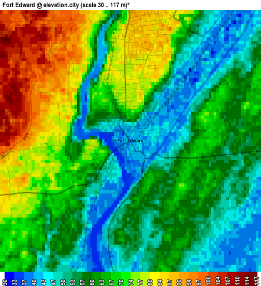
Below is the Elevation map of Fort Edward, which displays elevation range with different colors. Scale of the first map is from 30 to 117 m (98 to 384 ft) with average elevation of 64 meters (=210 ft) [note 1]
These maps also provides idea of topography and contour of this city, they are displayed at different zoom levels. More info about maps, scale and edge coordinates you can find below images.
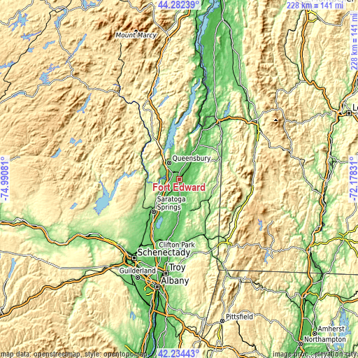
| \ | Map #1 | Topo.Map |
| Scale [m] | 30..117 m | × |
| Scale [ft] | 98..384 ft | × |
| Average | 64 m = 210 ft | × |
| Width | 7.12 km = 4.4 mi | 227.7 km = 141.5 mi |
| Height | 7.12 km = 4.4 mi | 227.7 km = 141.5 mi |
| ↑Max Latitude | 43.299011° | 44.28239° |
| Latitude at center | 43.26702° | 43.26702° |
| ↓Min Latitude | 43.235012° | 42.23443° |
| ← Min Longitude | -73.628505° | -74.99081° |
| Longitude center | -73.58456° | -73.58456° |
| →Max Longitude | -73.540615° | -72.17831° |
Nearby cities:
Cities around Fort Edward sort by population:
• Queensbury elevation 101 m
12.5 km,  349°
349°
• Glens Falls 106 m
6.7 km,  314°
314°
• Glens Falls North 143 m
11 km, 313°
• Hudson Falls 93 m
3.7 km,  358°
358°
• West Glens Falls 117 m
8.8 km,  294°
294°
• Northumberland 32 m
15.5 km,  181°
181°
• South Glens Falls 104 m
5.4 km, 311°
• Corinth 186 m
20.2 km,  262°
262°
• Hartford 118 m
18.8 km,  55°
55°
• Greenwich 117 m
20.8 km,  160°
160°
• Schuylerville 44 m
18.6 km, 179°
• Lake Luzerne 171 m
20.9 km,  284°
284°
Multilingual:
 En español:
Fort Edward elevación 42 m.
 En France:
Fort Edward élévation 42 m.
 Auf Deutsch:
Fort Edward höhe über dem Meeresspiegel ist 42 m.

Sources and notes:
- [note 1] Map square and city borders are not equal. Map elevation data is calculated only from area inside that square.
- [src 1] Elevation data from geonames database provided with same terms of usage.
- [src 2] The elevation map of Fort Edward is generated using elevation data from NASA's 3 arcsec (90m) resolution SRTM data.
- [src 3] Base (background) map © OpenStreetMap contributors tiles are generated by Geofabrik and OpenTopoMap.
Copyright & License:
This Fort Edward Elevation Map is licensed under CC BY-SA. You may reuse any part from this page, if you give a proper credit by linking to this URL:
 More info on terms of use page.