East Farmingdale elevation
East Farmingdale (New York, Suffolk County), United States elevation is 20 meters and East Farmingdale elevation in feet is 66 ft above sea level [src 1]. East Farmingdale is a populated place (feature code) with elevation that is 259 meters (850 ft) smaller than average city elevation in United States.
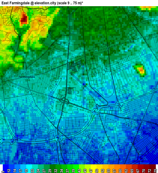
Below is the Elevation map of East Farmingdale, which displays elevation range with different colors. Scale of the first map is from 9 to 75 m (30 to 246 ft) with average elevation of 24.1 meters (=79 ft) [note 1]
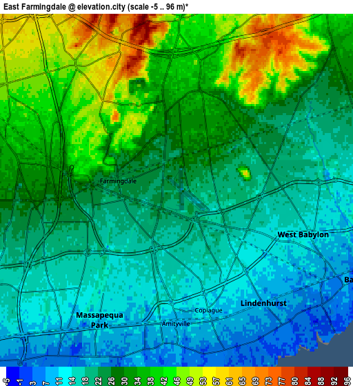
These maps also provides idea of topography and contour of this city, they are displayed at different zoom levels. More info about maps, scale and edge coordinates you can find below images.
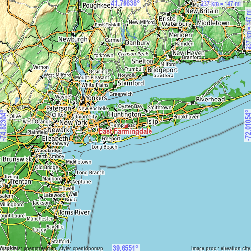
| \ | Map #1 | Map #2 | Topo.Map |
| Scale [m] | 9..75 m | -5..96 m | × |
| Scale [ft] | 30..246 ft | -16..315 ft | × |
| Average | 24.1 m = 79 ft | 26.7 m = 88 ft | × |
| Width | 7.41 km = 4.6 mi | 14.81 km = 9.2 mi | 237 km = 147.3 mi |
| Height | 7.41 km = 4.6 mi | 14.81 km = 9.2 mi | 237 km = 147.3 mi |
| ↑Max Latitude | 40.762563° | 40.79584° | 41.78638° |
| Latitude at center | 40.72927° | 40.72927° | 40.72927° |
| ↓Min Latitude | 40.69596° | 40.662633° | 39.6551° |
| ← Min Longitude | -73.460735° | -73.504681° | -74.82304° |
| Longitude center | -73.41679° | -73.41679° | -73.41679° |
| →Max Longitude | -73.372845° | -73.328899° | -72.01054° |
Nearby cities:
Cities around East Farmingdale sort by population:
• West Babylon elevation 14 m
5.4 km,  103°
103°
• Copiague 9 m
5.5 km,  164°
164°
• North Massapequa 17 m
4.9 km,  230°
230°
• North Amityville 12 m
3.6 km,  191°
191°
• Bethpage 34 m
5.7 km,  286°
286°
• South Farmingdale 20 m
2.2 km,  244°
244°
• North Lindenhurst 16 m
3.4 km,  119°
119°
• Wyandanch 18 m
5.5 km,  59°
59°
• Amityville 8 m
5.6 km,  180°
180°
• Farmingdale 23 m
2.4 km,  278°
278°
• Old Bethpage 57 m
4.8 km,  320°
320°
• Wheatley Heights 32 m
5.5 km,  45°
45°
Multilingual:
 En español:
East Farmingdale elevación 20 m.
 En France:
East Farmingdale élévation 20 m.
 Auf Deutsch:
East Farmingdale höhe über dem Meeresspiegel ist 20 m.

Sources and notes:
- [note 1] Map square and city borders are not equal. Map elevation data is calculated only from area inside that square.
- [src 1] Elevation data from geonames database provided with same terms of usage.
- [src 2] The elevation map of East Farmingdale is generated using elevation data from NASA's 3 arcsec (90m) resolution SRTM data.
- [src 3] Base (background) map © OpenStreetMap contributors tiles are generated by Geofabrik and OpenTopoMap.
Copyright & License:
This East Farmingdale Elevation Map is licensed under CC BY-SA. You may reuse any part from this page, if you give a proper credit by linking to this URL:
 More info on terms of use page.