Clinton elevation
Clinton (New York, Oneida County), United States elevation is 188 meters and Clinton elevation in feet is 617 ft above sea level [src 1]. Clinton is a populated place (feature code) with elevation that is 91 meters (299 ft) smaller than average city elevation in United States.
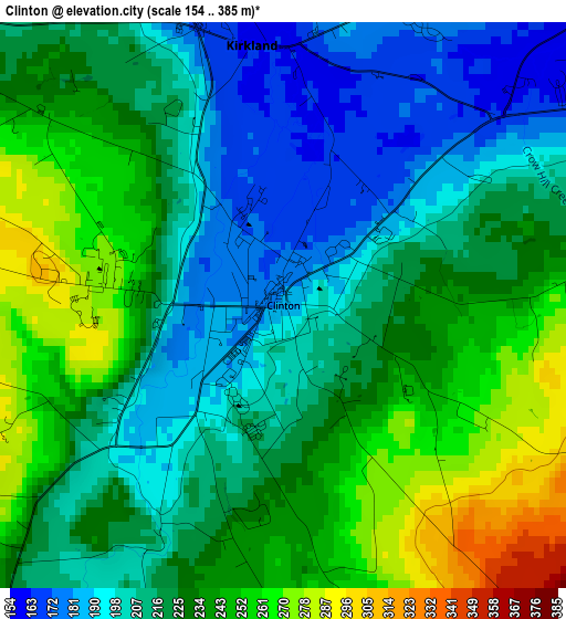
Below is the Elevation map of Clinton, which displays elevation range with different colors. Scale of the first map is from 154 to 385 m (505 to 1263 ft) with average elevation of 224.1 meters (=735 ft) [note 1]
These maps also provides idea of topography and contour of this city, they are displayed at different zoom levels. More info about maps, scale and edge coordinates you can find below images.
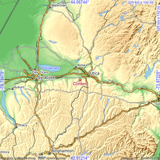
| \ | Map #1 | Topo.Map |
| Scale [m] | 154..385 m | × |
| Scale [ft] | 505..1263 ft | × |
| Average | 224.1 m = 735 ft | × |
| Width | 7.14 km = 4.4 mi | 228.5 km = 142 mi |
| Height | 7.14 km = 4.4 mi | 228.5 km = 142 mi |
| ↑Max Latitude | 43.080506° | 44.06744° |
| Latitude at center | 43.0484° | 43.0484° |
| ↓Min Latitude | 43.016277° | 42.01214° |
| ← Min Longitude | -75.422445° | -76.78475° |
| Longitude center | -75.3785° | -75.3785° |
| →Max Longitude | -75.334555° | -73.97225° |
Nearby cities:
Cities around Clinton sort by population:
• Utica elevation 143 m
13.2 km,  63°
63°
• Whitesboro 130 m
10.8 km,  40°
40°
• New York Mills 145 m
9.5 km,  48°
48°
• Yorkville 132 m
11.3 km, 50°
• Augusta 290 m
12.9 km,  230°
230°
• Clark Mills 159 m
4.9 km,  358°
358°
• New Hartford 163 m
7.9 km,  69°
69°
• Waterville 367 m
13 km,  180°
180°
• Chadwicks 216 m
9 km,  104°
104°
• Oriskany 130 m
12.7 km,  17°
17°
• Washington Mills 190 m
8.6 km,  88°
88°
• Vernon 194 m
13.5 km,  284°
284°
Multilingual:
 En español:
Clinton elevación 188 m.
 En France:
Clinton élévation 188 m.


Sources and notes:
- [note 1] Map square and city borders are not equal. Map elevation data is calculated only from area inside that square.
- [src 1] Elevation data from geonames database provided with same terms of usage.
- [src 2] The elevation map of Clinton is generated using elevation data from NASA's 3 arcsec (90m) resolution SRTM data.
- [src 3] Base (background) map © OpenStreetMap contributors tiles are generated by Geofabrik and OpenTopoMap.
Copyright & License:
This Clinton Elevation Map is licensed under CC BY-SA. You may reuse any part from this page, if you give a proper credit by linking to this URL:
 More info on terms of use page.