Alabama elevation
Alabama (New York, Genesee County), United States elevation is 198 meters and Alabama elevation in feet is 650 ft above sea level [src 1]. Alabama is a populated place (feature code) with elevation that is 81 meters (266 ft) smaller than average city elevation in United States.
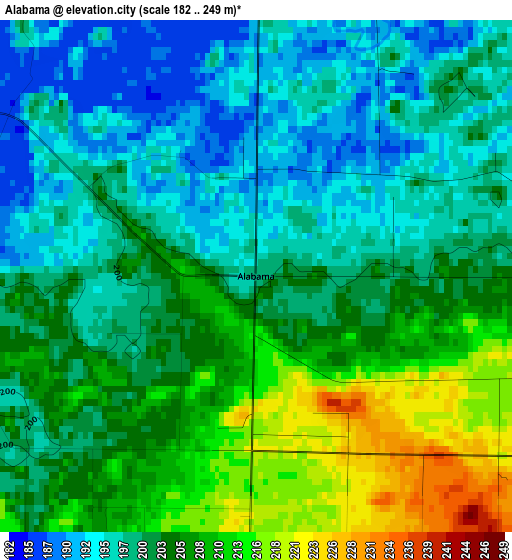
Below is the Elevation map of Alabama, which displays elevation range with different colors. Scale of the first map is from 182 to 249 m (597 to 817 ft) with average elevation of 202.4 meters (=664 ft) [note 1]
These maps also provides idea of topography and contour of this city, they are displayed at different zoom levels. More info about maps, scale and edge coordinates you can find below images.
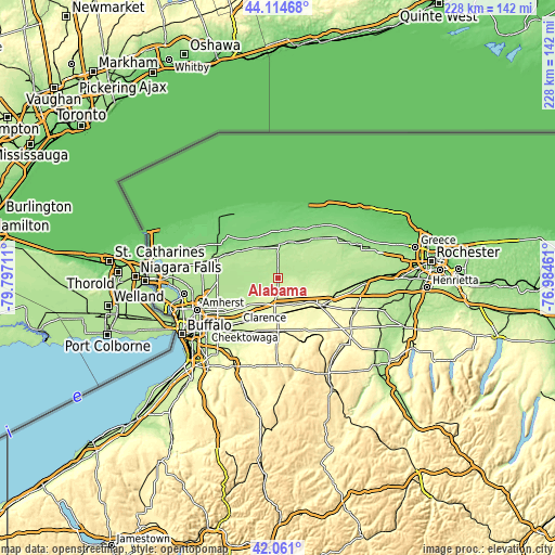
| \ | Map #1 | Topo.Map |
| Scale [m] | 182..249 m | × |
| Scale [ft] | 597..817 ft | × |
| Average | 202.4 m = 664 ft | × |
| Width | 7.14 km = 4.4 mi | 228.3 km = 141.9 mi |
| Height | 7.14 km = 4.4 mi | 228.3 km = 141.9 mi |
| ↑Max Latitude | 43.128531° | 44.11468° |
| Latitude at center | 43.09645° | 43.09645° |
| ↓Min Latitude | 43.064353° | 42.061° |
| ← Min Longitude | -78.434805° | -79.79711° |
| Longitude center | -78.39086° | -78.39086° |
| →Max Longitude | -78.346915° | -76.98461° |
Nearby cities:
Cities around Alabama sort by population:
• Batavia elevation 272 m
19.8 km,  123°
123°
• South Lockport 193 m
25.5 km,  283°
283°
• Albion 166 m
23.1 km,  43°
43°
• Medina 164 m
13.7 km,  1°
1°
• Akron 229 m
11.9 km,  225°
225°
• Clarence 230 m
21.1 km, 230°
• Alden 267 m
23.3 km,  200°
200°
• Clarence Center 197 m
22.2 km,  244°
244°
• Middleport 157 m
14.7 km,  331°
331°
• Oakfield 232 m
10.4 km,  109°
109°
• Rapids 181 m
20.3 km,  270°
270°
• Gasport 156 m
18.9 km,  307°
307°
Multilingual:
 En español:
Alabama elevación 198 m.
 En France:
Alabama élévation 198 m.


Sources and notes:
- [note 1] Map square and city borders are not equal. Map elevation data is calculated only from area inside that square.
- [src 1] Elevation data from geonames database provided with same terms of usage.
- [src 2] The elevation map of Alabama is generated using elevation data from NASA's 3 arcsec (90m) resolution SRTM data.
- [src 3] Base (background) map © OpenStreetMap contributors tiles are generated by Geofabrik and OpenTopoMap.
Copyright & License:
This Alabama Elevation Map is licensed under CC BY-SA. You may reuse any part from this page, if you give a proper credit by linking to this URL:
 More info on terms of use page.