West Freehold elevation
West Freehold (New Jersey, Monmouth County), United States elevation is 60 meters and West Freehold elevation in feet is 197 ft above sea level [src 1]. West Freehold is a populated place (feature code) with elevation that is 219 meters (719 ft) smaller than average city elevation in United States.
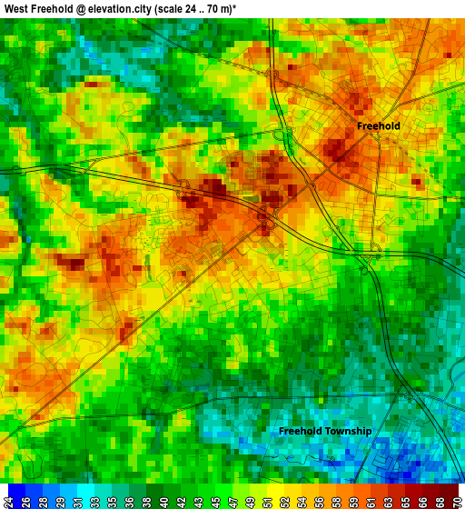
Below is the Elevation map of West Freehold, which displays elevation range with different colors. Scale of the first map is from 24 to 70 m (79 to 230 ft) with average elevation of 46.8 meters (=154 ft) [note 1]
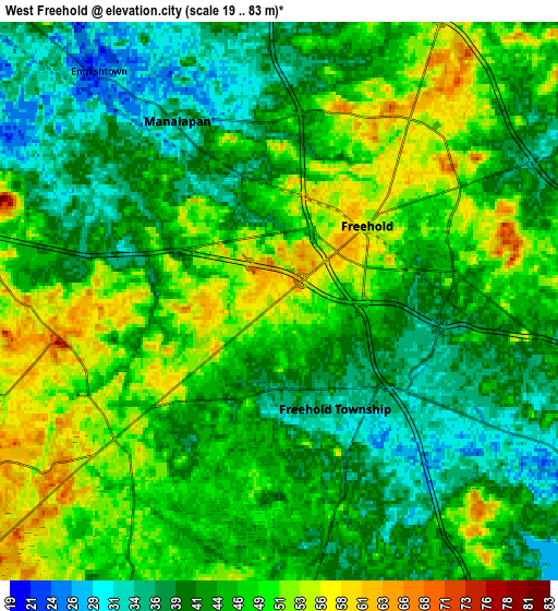
These maps also provides idea of topography and contour of this city, they are displayed at different zoom levels. More info about maps, scale and edge coordinates you can find below images.
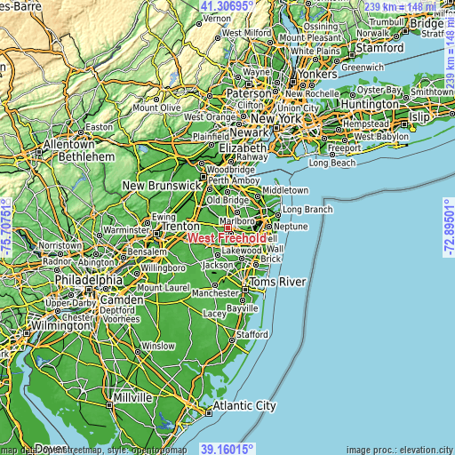
| \ | Map #1 | Map #2 | Topo.Map |
| Scale [m] | 24..70 m | 19..83 m | × |
| Scale [ft] | 79..230 ft | 62..272 ft | × |
| Average | 46.8 m = 154 ft | 44.7 m = 147 ft | × |
| Width | 7.46 km = 4.6 mi | 14.92 km = 9.3 mi | 238.7 km = 148.3 mi |
| Height | 7.46 km = 4.6 mi | 14.92 km = 9.3 mi | 238.7 km = 148.3 mi |
| ↑Max Latitude | 40.275596° | 40.309116° | 41.30695° |
| Latitude at center | 40.24206° | 40.24206° | 40.24206° |
| ↓Min Latitude | 40.208507° | 40.174938° | 39.16015° |
| ← Min Longitude | -74.345205° | -74.389151° | -75.70751° |
| Longitude center | -74.30126° | -74.30126° | -74.30126° |
| →Max Longitude | -74.257315° | -74.213369° | -72.89501° |
Nearby cities:
Cities around West Freehold sort by population:
• Marlboro elevation 58 m
9.4 km,  29°
29°
• Freehold 58 m
3.1 km,  49°
49°
• Robertsville 54 m
11.6 km,  5°
5°
• Yorketown 30 m
7.9 km,  337°
337°
• Morganville 56 m
15.7 km,  17°
17°
• East Freehold 56 m
6.1 km,  44°
44°
• Concordia 42 m
14.6 km,  301°
301°
• Clearbrook Park 36 m
15.8 km, 298°
• Whittingham 52 m
15.6 km,  308°
308°
• Vista Center 43 m
9.3 km,  188°
188°
• Englishtown 26 m
7.8 km,  321°
321°
• Farmingdale 25 m
12.4 km,  114°
114°
Multilingual:
 En español:
West Freehold elevación 60 m.
 En France:
West Freehold élévation 60 m.
 Auf Deutsch:
West Freehold höhe über dem Meeresspiegel ist 60 m.

Sources and notes:
- [note 1] Map square and city borders are not equal. Map elevation data is calculated only from area inside that square.
- [src 1] Elevation data from geonames database provided with same terms of usage.
- [src 2] The elevation map of West Freehold is generated using elevation data from NASA's 3 arcsec (90m) resolution SRTM data.
- [src 3] Base (background) map © OpenStreetMap contributors tiles are generated by Geofabrik and OpenTopoMap.
Copyright & License:
This West Freehold Elevation Map is licensed under CC BY-SA. You may reuse any part from this page, if you give a proper credit by linking to this URL:
 More info on terms of use page.