Ramtown elevation
Ramtown (New Jersey, Monmouth County), United States elevation is 26 meters and Ramtown elevation in feet is 85 ft above sea level [src 1]. Ramtown is a populated place (feature code) with elevation that is 253 meters (830 ft) smaller than average city elevation in United States.
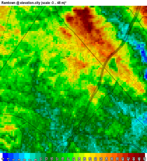
Below is the Elevation map of Ramtown, which displays elevation range with different colors. Scale of the first map is from -3 to 48 m (-10 to 157 ft) with average elevation of 20.2 meters (=66 ft) [note 1]
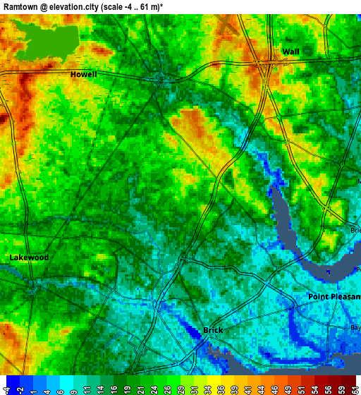
These maps also provides idea of topography and contour of this city, they are displayed at different zoom levels. More info about maps, scale and edge coordinates you can find below images.
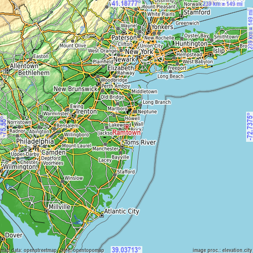
| \ | Map #1 | Map #2 | Topo.Map |
| Scale [m] | -3..48 m | -4..61 m | × |
| Scale [ft] | -10..157 ft | -13..200 ft | × |
| Average | 20.2 m = 66 ft | 21.4 m = 70 ft | × |
| Width | 7.47 km = 4.6 mi | 14.95 km = 9.3 mi | 239.1 km = 148.6 mi |
| Height | 7.47 km = 4.6 mi | 14.95 km = 9.3 mi | 239.1 km = 148.6 mi |
| ↑Max Latitude | 40.154546° | 40.188125° | 41.18777° |
| Latitude at center | 40.12095° | 40.12095° | 40.12095° |
| ↓Min Latitude | 40.087337° | 40.053708° | 39.03713° |
| ← Min Longitude | -74.187695° | -74.231641° | -75.55° |
| Longitude center | -74.14375° | -74.14375° | -74.14375° |
| →Max Longitude | -74.099805° | -74.055859° | -72.7375° |
Nearby cities:
Cities around Ramtown sort by population:
• Lakewood elevation 23 m
6.8 km,  247°
247°
• Point Pleasant 7 m
7.7 km,  123°
123°
• Manasquan 8 m
8.1 km,  85°
85°
• Brielle 9 m
7.6 km,  101°
101°
• Spring Lake Heights 8 m
10.1 km,  71°
71°
• Point Pleasant Beach 4 m
8.8 km,  112°
112°
• Leisure Village 22 m
9.4 km,  201°
201°
• Leisure Village East 12 m
10.2 km,  189°
189°
• Spring Lake 7 m
10.5 km, 69°
• West Belmar 8 m
10.7 km,  59°
59°
• Sea Girt 11 m
9.4 km,  82°
82°
• Farmingdale 25 m
8.7 km,  345°
345°
Multilingual:
 En español:
Ramtown elevación 26 m.
 En France:
Ramtown élévation 26 m.


Sources and notes:
- [note 1] Map square and city borders are not equal. Map elevation data is calculated only from area inside that square.
- [src 1] Elevation data from geonames database provided with same terms of usage.
- [src 2] The elevation map of Ramtown is generated using elevation data from NASA's 3 arcsec (90m) resolution SRTM data.
- [src 3] Base (background) map © OpenStreetMap contributors tiles are generated by Geofabrik and OpenTopoMap.
Copyright & License:
This Ramtown Elevation Map is licensed under CC BY-SA. You may reuse any part from this page, if you give a proper credit by linking to this URL:
 More info on terms of use page.