Bogota elevation
Bogota (New Jersey, Bergen County), United States elevation is 17 meters and Bogota elevation in feet is 56 ft above sea level [src 1]. Bogota is a populated place (feature code) with elevation that is 262 meters (860 ft) smaller than average city elevation in United States.
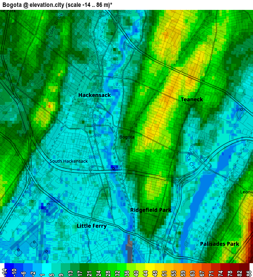
Below is the Elevation map of Bogota, which displays elevation range with different colors. Scale of the first map is from -14 to 86 m (-46 to 282 ft) with average elevation of 15.8 meters (=52 ft) [note 1]
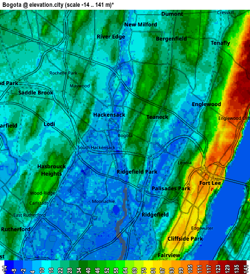
These maps also provides idea of topography and contour of this city, they are displayed at different zoom levels. More info about maps, scale and edge coordinates you can find below images.
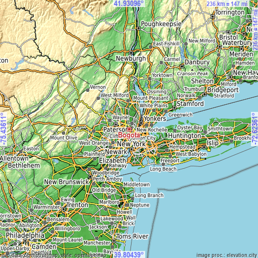
| \ | Map #1 | Map #2 | Topo.Map |
| Scale [m] | -14..86 m | -14..141 m | × |
| Scale [ft] | -46..282 ft | -46..463 ft | × |
| Average | 15.8 m = 52 ft | 25.7 m = 84 ft | × |
| Width | 7.39 km = 4.6 mi | 14.78 km = 9.2 mi | 236.5 km = 147 mi |
| Height | 7.39 km = 4.6 mi | 14.78 km = 9.2 mi | 236.4 km = 146.9 mi |
| ↑Max Latitude | 40.90943° | 40.942633° | 41.93096° |
| Latitude at center | 40.87621° | 40.87621° | 40.87621° |
| ↓Min Latitude | 40.842974° | 40.80972° | 39.80439° |
| ← Min Longitude | -74.073805° | -74.117751° | -75.43611° |
| Longitude center | -74.02986° | -74.02986° | -74.02986° |
| →Max Longitude | -73.985915° | -73.941969° | -72.62361° |
Nearby cities:
Cities around Bogota sort by population:
• Hackensack elevation 8 m
1.6 km,  313°
313°
• Teaneck 42 m
2.6 km,  26°
26°
• Lodi 10 m
4.5 km,  278°
278°
• Palisades Park 32 m
4.1 km,  139°
139°
• Ridgefield Park 30 m
2.2 km,  161°
161°
• Hasbrouck Heights 42 m
4.7 km,  244°
244°
• Ridgefield 12 m
5 km, 159°
• Little Ferry 4 m
2.8 km,  201°
201°
• Maywood 31 m
4 km,  317°
317°
• Leonia 32 m
3.9 km,  115°
115°
• Rochelle Park 21 m
5.1 km, 312°
• Moonachie 4 m
4.1 km, 198°
Multilingual:
 En español:
Bogota elevación 17 m.
 En France:
Bogota élévation 17 m.


Sources and notes:
- [note 1] Map square and city borders are not equal. Map elevation data is calculated only from area inside that square.
- [src 1] Elevation data from geonames database provided with same terms of usage.
- [src 2] The elevation map of Bogota is generated using elevation data from NASA's 3 arcsec (90m) resolution SRTM data.
- [src 3] Base (background) map © OpenStreetMap contributors tiles are generated by Geofabrik and OpenTopoMap.
Copyright & License:
This Bogota Elevation Map is licensed under CC BY-SA. You may reuse any part from this page, if you give a proper credit by linking to this URL:
 More info on terms of use page.