Lee elevation
Lee (New Hampshire, Strafford County), United States elevation is 57 meters and Lee elevation in feet is 187 ft above sea level [src 1]. Lee is a populated place (feature code) with elevation that is 222 meters (728 ft) smaller than average city elevation in United States.
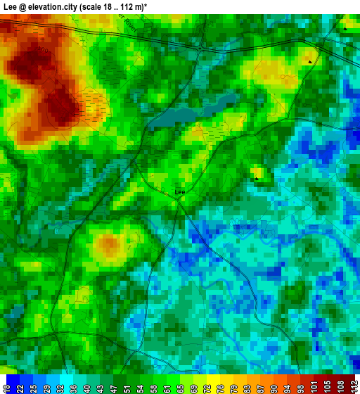
Below is the Elevation map of Lee, which displays elevation range with different colors. Scale of the first map is from 18 to 112 m (59 to 367 ft) with average elevation of 51.3 meters (=168 ft) [note 1]
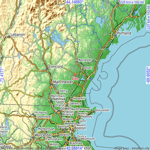
These maps also provides idea of topography and contour of this city, they are displayed at different zoom levels. More info about maps, scale and edge coordinates you can find below images.
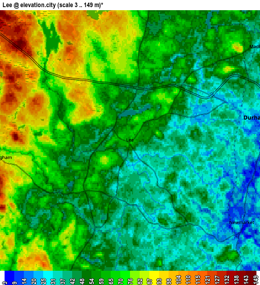
| \ | Map #1 | Map #2 | Topo.Map |
| Scale [m] | 18..112 m | 3..149 m | × |
| Scale [ft] | 59..367 ft | 10..489 ft | × |
| Average | 51.3 m = 168 ft | 57.9 m = 190 ft | × |
| Width | 7.13 km = 4.4 mi | 14.27 km = 8.9 mi | 228.2 km = 141.8 mi |
| Height | 7.13 km = 4.4 mi | 14.27 km = 8.9 mi | 228.2 km = 141.8 mi |
| ↑Max Latitude | 43.155207° | 43.187257° | 44.14093° |
| Latitude at center | 43.12314° | 43.12314° | 43.12314° |
| ↓Min Latitude | 43.091057° | 43.058956° | 42.08814° |
| ← Min Longitude | -71.055395° | -71.099341° | -72.4177° |
| Longitude center | -71.01145° | -71.01145° | -71.01145° |
| →Max Longitude | -70.967505° | -70.923559° | -69.6052° |
Nearby cities:
Cities around Lee sort by population:
• Dover elevation 23 m
13.9 km,  53°
53°
• Durham 17 m
7 km,  80°
80°
• Exeter 12 m
16.6 km,  161°
161°
• Barrington 117 m
11.5 km,  345°
345°
• Stratham Station 16 m
12.2 km,  129°
129°
• Newmarket 16 m
7.6 km, 125°
• Nottingham 84 m
7.2 km,  262°
262°
• Northwood 173 m
13.8 km,  304°
304°
• Brentwood 37 m
16.8 km,  197°
197°
• Raymond 64 m
17 km,  235°
235°
• Epping 49 m
11.2 km,  207°
207°
• Madbury 40 m
8.8 km, 54°
Multilingual:
 En español:
Lee elevación 57 m.
 En France:
Lee élévation 57 m.


Sources and notes:
- [note 1] Map square and city borders are not equal. Map elevation data is calculated only from area inside that square.
- [src 1] Elevation data from geonames database provided with same terms of usage.
- [src 2] The elevation map of Lee is generated using elevation data from NASA's 3 arcsec (90m) resolution SRTM data.
- [src 3] Base (background) map © OpenStreetMap contributors tiles are generated by Geofabrik and OpenTopoMap.
Copyright & License:
This Lee Elevation Map is licensed under CC BY-SA. You may reuse any part from this page, if you give a proper credit by linking to this URL:
 More info on terms of use page.