David City elevation
David City (Nebraska, Butler County), United States elevation is 491 meters and David City elevation in feet is 1611 ft above sea level [src 1]. David City is a seat of a second-order administrative division (feature code) with elevation that is 212 meters (696 ft) bigger than average city elevation in United States.
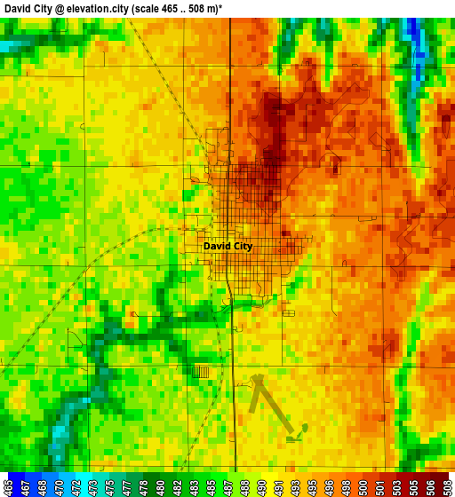
Below is the Elevation map of David City, which displays elevation range with different colors. Scale of the first map is from 465 to 508 m (1526 to 1667 ft) with average elevation of 491.2 meters (=1612 ft) [note 1]
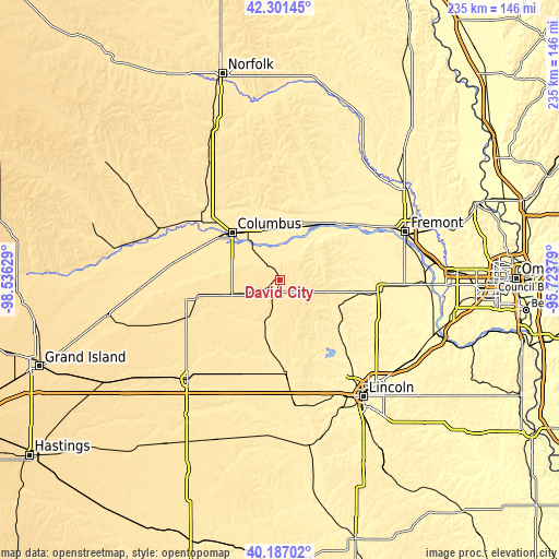
These maps also provides idea of topography and contour of this city, they are displayed at different zoom levels. More info about maps, scale and edge coordinates you can find below images.
| \ | Map #1 | Topo.Map |
| Scale [m] | 465..508 m | × |
| Scale [ft] | 1526..1667 ft | × |
| Average | 491.2 m = 1612 ft | × |
| Width | 7.35 km = 4.6 mi | 235.1 km = 146.1 mi |
| Height | 7.35 km = 4.6 mi | 235.1 km = 146.1 mi |
| ↑Max Latitude | 41.28582° | 42.30145° |
| Latitude at center | 41.25279° | 41.25279° |
| ↓Min Latitude | 41.219743° | 40.18702° |
| ← Min Longitude | -97.173985° | -98.53629° |
| Longitude center | -97.13004° | -97.13004° |
| →Max Longitude | -97.086095° | -95.72379° |
Nearby cities:
Cities around David City sort by population:
• Fremont elevation 366 m
56.4 km,  69°
69°
• Columbus 442 m
28 km,  314°
314°
• York 490 m
57.7 km,  222°
222°
• Seward 456 m
38.5 km,  176°
176°
• Schuyler 412 m
22.4 km,  15°
15°
• Wahoo 371 m
42.9 km,  96°
96°
• Waverly 347 m
62.7 km,  126°
126°
• Milford 444 m
53.6 km,  172°
172°
• North Bend 390 m
37.4 km,  51°
51°
• Yutan 358 m
61.3 km,  90°
90°
• Stromsburg 513 m
42.2 km,  248°
248°
• Osceola 510 m
35.9 km,  256°
256°
Multilingual:
 En español:
David City elevación 491 m.
 En France:
David City élévation 491 m.
 Auf Deutsch:
David City höhe über dem Meeresspiegel ist 491 m.

Sources and notes:
- [note 1] Map square and city borders are not equal. Map elevation data is calculated only from area inside that square.
- [src 1] Elevation data from geonames database provided with same terms of usage.
- [src 2] The elevation map of David City is generated using elevation data from NASA's 3 arcsec (90m) resolution SRTM data.
- [src 3] Base (background) map © OpenStreetMap contributors tiles are generated by Geofabrik and OpenTopoMap.
Copyright & License:
This David City Elevation Map is licensed under CC BY-SA. You may reuse any part from this page, if you give a proper credit by linking to this URL:
 More info on terms of use page.