Cooperstown elevation
Cooperstown (North Dakota, Griggs County), United States elevation is 435 meters and Cooperstown elevation in feet is 1427 ft above sea level [src 1]. Cooperstown is a seat of a second-order administrative division (feature code) with elevation that is 156 meters (512 ft) bigger than average city elevation in United States.
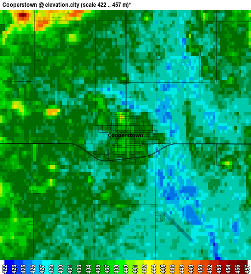
Below is the Elevation map of Cooperstown, which displays elevation range with different colors. Scale of the first map is from 422 to 457 m (1385 to 1499 ft) with average elevation of 432.2 meters (=1418 ft) [note 1]
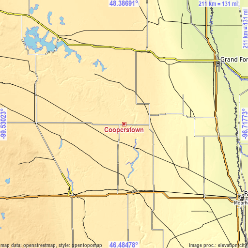
These maps also provides idea of topography and contour of this city, they are displayed at different zoom levels. More info about maps, scale and edge coordinates you can find below images.
| \ | Map #1 | Topo.Map |
| Scale [m] | 422..457 m | × |
| Scale [ft] | 1385..1499 ft | × |
| Average | 432.2 m = 1418 ft | × |
| Width | 6.61 km = 4.1 mi | 211.5 km = 131.4 mi |
| Height | 6.61 km = 4.1 mi | 211.5 km = 131.4 mi |
| ↑Max Latitude | 47.474152° | 48.38691° |
| Latitude at center | 47.44444° | 47.44444° |
| ↓Min Latitude | 47.414711° | 46.48478° |
| ← Min Longitude | -98.167925° | -99.53023° |
| Longitude center | -98.12398° | -98.12398° |
| →Max Longitude | -98.080035° | -96.71773° |
Nearby cities:
Cities around Cooperstown sort by population:
• Jamestown elevation 427 m
74 km,  216°
216°
• Valley City 372 m
58.7 km,  171°
171°
• Grand Forks Air Force Base 271 m
79.2 km,  44°
44°
• Carrington 483 m
75.4 km,  270°
270°
• Mayville 300 m
60.4 km,  84°
84°
• Hillsboro 277 m
80 km,  93°
93°
• New Rockford 467 m
80.5 km,  288°
288°
• Larimore 347 m
63.5 km, 35°
• Fort Totten 452 m
88.2 km,  312°
312°
• Thompson 264 m
84.4 km,  64°
64°
• Lakota 461 m
68.4 km,  346°
346°
• Finley 443 m
23 km,  70°
70°
Multilingual:
 En español:
Cooperstown elevación 435 m.
 En France:
Cooperstown élévation 435 m.
 Auf Deutsch:
Cooperstown höhe über dem Meeresspiegel ist 435 m.

Sources and notes:
- [note 1] Map square and city borders are not equal. Map elevation data is calculated only from area inside that square.
- [src 1] Elevation data from geonames database provided with same terms of usage.
- [src 2] The elevation map of Cooperstown is generated using elevation data from NASA's 3 arcsec (90m) resolution SRTM data.
- [src 3] Base (background) map © OpenStreetMap contributors tiles are generated by Geofabrik and OpenTopoMap.
Copyright & License:
This Cooperstown Elevation Map is licensed under CC BY-SA. You may reuse any part from this page, if you give a proper credit by linking to this URL:
 More info on terms of use page.