Cando elevation
Cando (North Dakota, Towner County), United States elevation is 449 meters and Cando elevation in feet is 1473 ft above sea level [src 1]. Cando is a seat of a second-order administrative division (feature code) with elevation that is 170 meters (558 ft) bigger than average city elevation in United States.
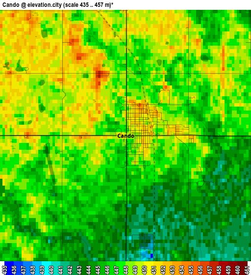
Below is the Elevation map of Cando, which displays elevation range with different colors. Scale of the first map is from 435 to 457 m (1427 to 1499 ft) with average elevation of 447 meters (=1467 ft) [note 1]
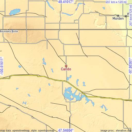
These maps also provides idea of topography and contour of this city, they are displayed at different zoom levels. More info about maps, scale and edge coordinates you can find below images.
| \ | Map #1 | Topo.Map |
| Scale [m] | 435..457 m | × |
| Scale [ft] | 1427..1499 ft | × |
| Average | 447 m = 1467 ft | × |
| Width | 6.48 km = 4 mi | 207.3 km = 128.8 mi |
| Height | 6.48 km = 4 mi | 207.3 km = 128.8 mi |
| ↑Max Latitude | 48.515788° | 49.41017° |
| Latitude at center | 48.48667° | 48.48667° |
| ↓Min Latitude | 48.457535° | 47.54604° |
| ← Min Longitude | -99.253805° | -100.61611° |
| Longitude center | -99.20986° | -99.20986° |
| →Max Longitude | -99.165915° | -97.80361° |
Nearby cities:
Cities around Cando sort by population:
• Devils Lake elevation 439 m
48.8 km,  148°
148°
• Rugby 471 m
59.5 km,  257°
257°
• Belcourt 598 m
55.5 km,  314°
314°
• Langdon 493 m
68.9 km,  63°
63°
• Harvey 487 m
96.2 km,  214°
214°
• New Rockford 467 m
89.9 km,  176°
176°
• Rolla 554 m
51 km,  324°
324°
• Fort Totten 452 m
58.6 km,  164°
164°
• Shell Valley 540 m
59.3 km, 305°
• Lakota 461 m
81.3 km,  127°
127°
• Towner 450 m
89.6 km, 259°
• Minnewaukan 443 m
46.3 km, 183°
Multilingual:
 En español:
Cando elevación 449 m.
 En France:
Cando élévation 449 m.


Sources and notes:
- [note 1] Map square and city borders are not equal. Map elevation data is calculated only from area inside that square.
- [src 1] Elevation data from geonames database provided with same terms of usage.
- [src 2] The elevation map of Cando is generated using elevation data from NASA's 3 arcsec (90m) resolution SRTM data.
- [src 3] Base (background) map © OpenStreetMap contributors tiles are generated by Geofabrik and OpenTopoMap.
Copyright & License:
This Cando Elevation Map is licensed under CC BY-SA. You may reuse any part from this page, if you give a proper credit by linking to this URL:
 More info on terms of use page.