Scandia elevation
Scandia (Minnesota, Washington County), United States elevation is 317 meters and Scandia elevation in feet is 1040 ft above sea level [src 1]. Scandia is a populated place (feature code) with elevation that is 38 meters (125 ft) bigger than average city elevation in United States.
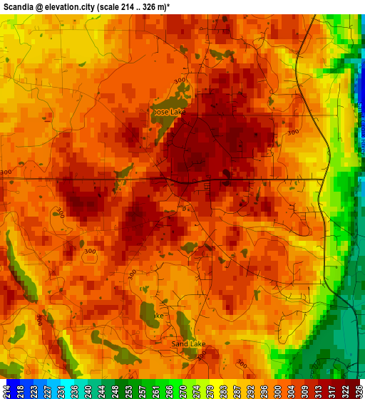
Below is the Elevation map of Scandia, which displays elevation range with different colors. Scale of the first map is from 214 to 326 m (702 to 1070 ft) with average elevation of 295.8 meters (=970 ft) [note 1]
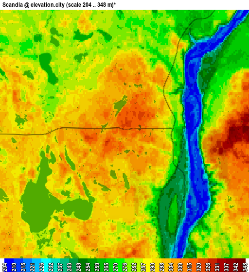
These maps also provides idea of topography and contour of this city, they are displayed at different zoom levels. More info about maps, scale and edge coordinates you can find below images.
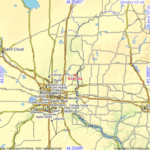
| \ | Map #1 | Map #2 | Topo.Map |
| Scale [m] | 214..326 m | 204..348 m | × |
| Scale [ft] | 702..1070 ft | 669..1142 ft | × |
| Average | 295.8 m = 970 ft | 284 m = 932 ft | × |
| Width | 6.88 km = 4.3 mi | 13.76 km = 8.6 mi | 220.1 km = 136.8 mi |
| Height | 6.88 km = 4.3 mi | 13.76 km = 8.6 mi | 220.1 km = 136.8 mi |
| ↑Max Latitude | 45.284508° | 45.315419° | 46.23491° |
| Latitude at center | 45.25358° | 45.25358° | 45.25358° |
| ↓Min Latitude | 45.222635° | 45.191674° | 44.25499° |
| ← Min Longitude | -92.849715° | -92.893661° | -94.21202° |
| Longitude center | -92.80577° | -92.80577° | -92.80577° |
| →Max Longitude | -92.761825° | -92.717879° | -91.39952° |
Nearby cities:
Cities around Scandia sort by population:
• Forest Lake elevation 276 m
14.3 km,  281°
281°
• Hugo 282 m
18 km,  234°
234°
• Wyoming 272 m
17.6 km,  301°
301°
• Chisago City 280 m
14.9 km,  333°
333°
• Lindstrom 283 m
15.5 km,  347°
347°
• Grant 305 m
20.5 km,  203°
203°
• Columbus 274 m
19.2 km,  273°
273°
• Somerset 257 m
17.7 km,  144°
144°
• Osceola 245 m
10.8 km,  46°
46°
• Shafer 286 m
15.5 km,  17°
17°
• Taylors Falls 226 m
20.4 km,  36°
36°
• Center City 284 m
15.6 km,  356°
356°
Multilingual:
 En español:
Scandia elevación 317 m.
 En France:
Scandia élévation 317 m.


Sources and notes:
- [note 1] Map square and city borders are not equal. Map elevation data is calculated only from area inside that square.
- [src 1] Elevation data from geonames database provided with same terms of usage.
- [src 2] The elevation map of Scandia is generated using elevation data from NASA's 3 arcsec (90m) resolution SRTM data.
- [src 3] Base (background) map © OpenStreetMap contributors tiles are generated by Geofabrik and OpenTopoMap.
Copyright & License:
This Scandia Elevation Map is licensed under CC BY-SA. You may reuse any part from this page, if you give a proper credit by linking to this URL:
 More info on terms of use page.