Minnetonka elevation
Minnetonka (Minnesota, Hennepin County), United States elevation is 272 meters and Minnetonka elevation in feet is 892 ft above sea level [src 1]. Minnetonka is a populated place (feature code) with elevation that is 7 meters (23 ft) smaller than average city elevation in United States.
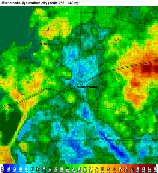
Below is the Elevation map of Minnetonka, which displays elevation range with different colors. Scale of the first map is from 255 to 340 m (837 to 1115 ft) with average elevation of 287.5 meters (=943 ft) [note 1]
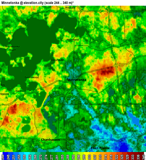
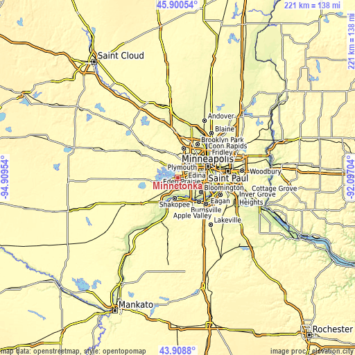
These maps also provides idea of topography and contour of this city, they are displayed at different zoom levels. More info about maps, scale and edge coordinates you can find below images.
| \ | Map #1 | Map #2 | Topo.Map |
| Scale [m] | 255..340 m | 244..340 m | × |
| Scale [ft] | 837..1115 ft | 801..1115 ft | × |
| Average | 287.5 m = 943 ft | 285.3 m = 936 ft | × |
| Width | 6.92 km = 4.3 mi | 13.84 km = 8.6 mi | 221.5 km = 137.6 mi |
| Height | 6.92 km = 4.3 mi | 13.84 km = 8.6 mi | 221.5 km = 137.6 mi |
| ↑Max Latitude | 44.944413° | 44.975508° | 45.90054° |
| Latitude at center | 44.9133° | 44.9133° | 44.9133° |
| ↓Min Latitude | 44.882171° | 44.851024° | 43.9088° |
| ← Min Longitude | -93.547235° | -93.591181° | -94.90954° |
| Longitude center | -93.50329° | -93.50329° | -93.50329° |
| →Max Longitude | -93.459345° | -93.415399° | -92.09704° |
Nearby cities:
Cities around Minnetonka sort by population:
• Eden Prairie elevation 271 m
7 km,  158°
158°
• Minnetonka Mills 289 m
5.7 km,  57°
57°
• Chanhassen 296 m
6.1 km,  200°
200°
• Hopkins 316 m
3.4 km,  67°
67°
• Orono 296 m
10.2 km,  309°
309°
• Shorewood 298 m
6.9 km,  258°
258°
• Wayzata 285 m
6.8 km,  357°
357°
• Deephaven 298 m
2.4 km,  320°
320°
• Excelsior 288 m
5.1 km, 257°
• Long Lake 290 m
9.8 km,  326°
326°
• Spring Park 289 m
10.4 km,  283°
283°
• Tonka Bay 296 m
7.1 km,  265°
265°
Multilingual:
 En español:
Minnetonka elevación 272 m.
 En France:
Minnetonka élévation 272 m.
 Auf Deutsch:
Minnetonka höhe über dem Meeresspiegel ist 272 m.

Sources and notes:
- [note 1] Map square and city borders are not equal. Map elevation data is calculated only from area inside that square.
- [src 1] Elevation data from geonames database provided with same terms of usage.
- [src 2] The elevation map of Minnetonka is generated using elevation data from NASA's 3 arcsec (90m) resolution SRTM data.
- [src 3] Base (background) map © OpenStreetMap contributors tiles are generated by Geofabrik and OpenTopoMap.
Copyright & License:
This Minnetonka Elevation Map is licensed under CC BY-SA. You may reuse any part from this page, if you give a proper credit by linking to this URL:
 More info on terms of use page.