Mendota Heights elevation
Mendota Heights (Minnesota, Dakota County), United States elevation is 270 meters and Mendota Heights elevation in feet is 886 ft above sea level [src 1]. Mendota Heights is a populated place (feature code) with elevation that is 9 meters (30 ft) smaller than average city elevation in United States.
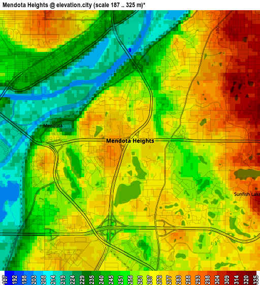
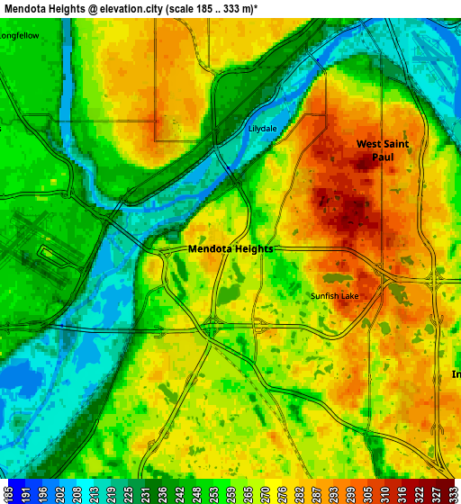
Below is the Elevation map of Mendota Heights, which displays elevation range with different colors. Scale of the first map is from 187 to 325 m (614 to 1066 ft) with average elevation of 261.4 meters (=858 ft) [note 1]
These maps also provides idea of topography and contour of this city, they are displayed at different zoom levels. More info about maps, scale and edge coordinates you can find below images.
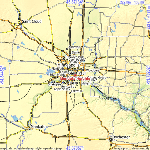
| \ | Map #1 | Map #2 | Topo.Map |
| Scale [m] | 187..325 m | 185..333 m | × |
| Scale [ft] | 614..1066 ft | 607..1093 ft | × |
| Average | 261.4 m = 858 ft | 259.6 m = 852 ft | × |
| Width | 6.92 km = 4.3 mi | 13.85 km = 8.6 mi | 221.6 km = 137.7 mi |
| Height | 6.92 km = 4.3 mi | 13.85 km = 8.6 mi | 221.6 km = 137.7 mi |
| ↑Max Latitude | 44.914709° | 44.945821° | 45.87134° |
| Latitude at center | 44.88358° | 44.88358° | 44.88358° |
| ↓Min Latitude | 44.852434° | 44.821272° | 43.87857° |
| ← Min Longitude | -93.182215° | -93.226161° | -94.54452° |
| Longitude center | -93.13827° | -93.13827° | -93.13827° |
| →Max Longitude | -93.094325° | -93.050379° | -91.73202° |
Nearby cities:
Cities around Mendota Heights sort by population:
• Saint Paul elevation 242 m
7.6 km,  27°
27°
• Bloomington 251 m
13.5 km,  249°
249°
• Eagan 289 m
9.1 km,  194°
194°
• Maplewood 300 m
13.7 km,  55°
55°
• Richfield 251 m
11.4 km,  269°
269°
• Roseville 290 m
13.7 km,  353°
353°
• Inver Grove Heights 266 m
8.5 km,  117°
117°
• South Saint Paul 220 m
8.2 km,  82°
82°
• West Saint Paul 311 m
4.6 km,  38°
38°
• Falcon Heights 291 m
12.2 km, 349°
• Saint Paul Park 237 m
12.5 km,  111°
111°
• Newport 226 m
11 km,  100°
100°
Multilingual:
 En español:
Mendota Heights elevación 270 m.
 En France:
Mendota Heights élévation 270 m.
 Auf Deutsch:
Mendota Heights höhe über dem Meeresspiegel ist 270 m.

Sources and notes:
- [note 1] Map square and city borders are not equal. Map elevation data is calculated only from area inside that square.
- [src 1] Elevation data from geonames database provided with same terms of usage.
- [src 2] The elevation map of Mendota Heights is generated using elevation data from NASA's 3 arcsec (90m) resolution SRTM data.
- [src 3] Base (background) map © OpenStreetMap contributors tiles are generated by Geofabrik and OpenTopoMap.
Copyright & License:
This Mendota Heights Elevation Map is licensed under CC BY-SA. You may reuse any part from this page, if you give a proper credit by linking to this URL:
 More info on terms of use page.