Madison Lake elevation
Madison Lake (Minnesota, Blue Earth County), United States elevation is 318 meters and Madison Lake elevation in feet is 1043 ft above sea level [src 1]. Madison Lake is a populated place (feature code) with elevation that is 39 meters (128 ft) bigger than average city elevation in United States.
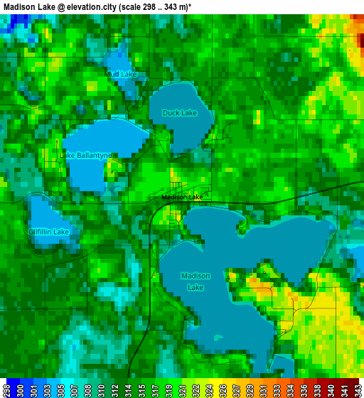
Below is the Elevation map of Madison Lake, which displays elevation range with different colors. Scale of the first map is from 298 to 343 m (978 to 1125 ft) with average elevation of 313.6 meters (=1029 ft) [note 1]
These maps also provides idea of topography and contour of this city, they are displayed at different zoom levels. More info about maps, scale and edge coordinates you can find below images.
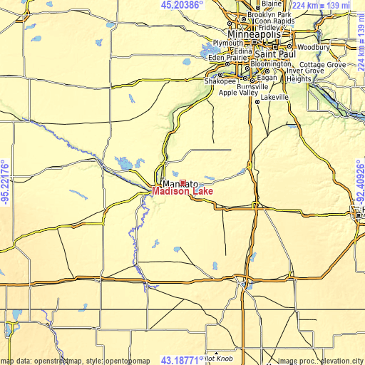
| \ | Map #1 | Topo.Map |
| Scale [m] | 298..343 m | × |
| Scale [ft] | 978..1125 ft | × |
| Average | 313.6 m = 1029 ft | × |
| Width | 7.01 km = 4.4 mi | 224.2 km = 139.3 mi |
| Height | 7.01 km = 4.4 mi | 224.2 km = 139.3 mi |
| ↑Max Latitude | 44.235904° | 45.20386° |
| Latitude at center | 44.20441° | 44.20441° |
| ↓Min Latitude | 44.172899° | 43.18771° |
| ← Min Longitude | -93.859455° | -95.22176° |
| Longitude center | -93.81551° | -93.81551° |
| →Max Longitude | -93.771565° | -92.40926° |
Nearby cities:
Cities around Madison Lake sort by population:
• Mankato elevation 245 m
16.2 km,  251°
251°
• North Mankato 307 m
17.7 km,  258°
258°
• Saint Peter 233 m
17.4 km,  319°
319°
• Waseca 351 m
28.3 km,  119°
119°
• Le Sueur 232 m
29.6 km,  344°
344°
• Montgomery 329 m
32 km,  35°
35°
• Eagle Lake 311 m
6.8 km,  230°
230°
• Le Center 322 m
21.7 km,  18°
18°
• Janesville 324 m
13 km,  138°
138°
• Waterville 309 m
19.8 km,  85°
85°
• Mapleton 318 m
32.6 km,  200°
200°
• Nicollet 298 m
30.7 km,  285°
285°
Multilingual:
 En español:
Madison Lake elevación 318 m.
 En France:
Madison Lake élévation 318 m.
 Auf Deutsch:
Madison Lake höhe über dem Meeresspiegel ist 318 m.

Sources and notes:
- [note 1] Map square and city borders are not equal. Map elevation data is calculated only from area inside that square.
- [src 1] Elevation data from geonames database provided with same terms of usage.
- [src 2] The elevation map of Madison Lake is generated using elevation data from NASA's 3 arcsec (90m) resolution SRTM data.
- [src 3] Base (background) map © OpenStreetMap contributors tiles are generated by Geofabrik and OpenTopoMap.
Copyright & License:
This Madison Lake Elevation Map is licensed under CC BY-SA. You may reuse any part from this page, if you give a proper credit by linking to this URL:
 More info on terms of use page.