Little Canada elevation
Little Canada (Minnesota, Ramsey County), United States elevation is 279 meters and Little Canada elevation in feet is 915 ft above sea level [src 1]. Little Canada is a populated place (feature code) with elevation that is 0 meters (0 ft) bigger than average city elevation in United States.
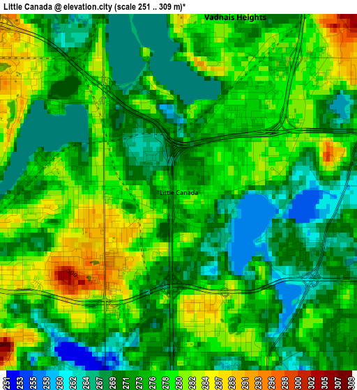
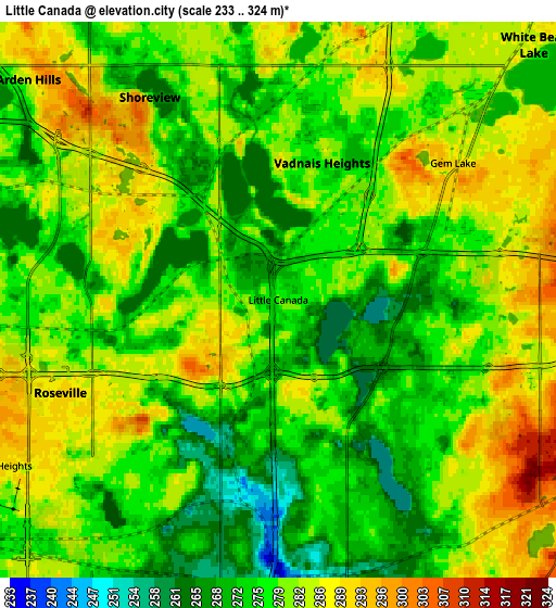
Below is the Elevation map of Little Canada, which displays elevation range with different colors. Scale of the first map is from 251 to 309 m (823 to 1014 ft) with average elevation of 274.7 meters (=901 ft) [note 1]
These maps also provides idea of topography and contour of this city, they are displayed at different zoom levels. More info about maps, scale and edge coordinates you can find below images.
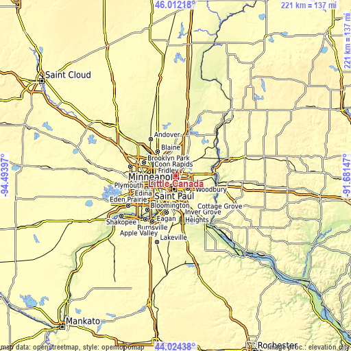
| \ | Map #1 | Map #2 | Topo.Map |
| Scale [m] | 251..309 m | 233..324 m | × |
| Scale [ft] | 823..1014 ft | 764..1063 ft | × |
| Average | 274.7 m = 901 ft | 278.6 m = 914 ft | × |
| Width | 6.91 km = 4.3 mi | 13.81 km = 8.6 mi | 221 km = 137.3 mi |
| Height | 6.91 km = 4.3 mi | 13.81 km = 8.6 mi | 221 km = 137.3 mi |
| ↑Max Latitude | 45.057961° | 45.088995° | 46.01218° |
| Latitude at center | 45.02691° | 45.02691° | 45.02691° |
| ↓Min Latitude | 44.995842° | 44.964757° | 44.02438° |
| ← Min Longitude | -93.131665° | -93.175611° | -94.49397° |
| Longitude center | -93.08772° | -93.08772° | -93.08772° |
| →Max Longitude | -93.043775° | -92.999829° | -91.68147° |
Nearby cities:
Cities around Little Canada sort by population:
• Saint Paul elevation 242 m
9.2 km,  182°
182°
• Roseville 290 m
5.9 km,  246°
246°
• Shoreview 287 m
7.5 km,  321°
321°
• White Bear Lake 284 m
8.9 km,  43°
43°
• New Brighton 266 m
9.9 km,  295°
295°
• Vadnais Heights 277 m
3.6 km,  17°
17°
• North Saint Paul 297 m
7.7 km,  102°
102°
• Arden Hills 282 m
6 km, 295°
• Falcon Heights 291 m
7.3 km,  237°
237°
• North Oaks 296 m
8.5 km,  4°
4°
• Lauderdale 288 m
9.8 km, 251°
• Birchwood 296 m
9.6 km,  66°
66°
Multilingual:
 En español:
Little Canada elevación 279 m.
 En France:
Little Canada élévation 279 m.
 Auf Deutsch:
Little Canada höhe über dem Meeresspiegel ist 279 m.

Sources and notes:
- [note 1] Map square and city borders are not equal. Map elevation data is calculated only from area inside that square.
- [src 1] Elevation data from geonames database provided with same terms of usage.
- [src 2] The elevation map of Little Canada is generated using elevation data from NASA's 3 arcsec (90m) resolution SRTM data.
- [src 3] Base (background) map © OpenStreetMap contributors tiles are generated by Geofabrik and OpenTopoMap.
Copyright & License:
This Little Canada Elevation Map is licensed under CC BY-SA. You may reuse any part from this page, if you give a proper credit by linking to this URL:
 More info on terms of use page.