Lexington elevation
Lexington (Minnesota, Anoka County), United States elevation is 276 meters and Lexington elevation in feet is 906 ft above sea level [src 1]. Lexington is a populated place (feature code) with elevation that is 3 meters (10 ft) smaller than average city elevation in United States.
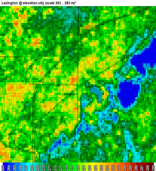
Below is the Elevation map of Lexington, which displays elevation range with different colors. Scale of the first map is from 263 to 283 m (863 to 928 ft) with average elevation of 273 meters (=896 ft) [note 1]
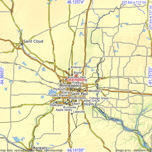
These maps also provides idea of topography and contour of this city, they are displayed at different zoom levels. More info about maps, scale and edge coordinates you can find below images.
| \ | Map #1 | Topo.Map |
| Scale [m] | 263..283 m | × |
| Scale [ft] | 863..928 ft | × |
| Average | 273 m = 896 ft | × |
| Width | 6.89 km = 4.3 mi | 220.6 km = 137.1 mi |
| Height | 6.89 km = 4.3 mi | 220.6 km = 137.1 mi |
| ↑Max Latitude | 45.173458° | 46.12574° |
| Latitude at center | 45.14247° | 45.14247° |
| ↓Min Latitude | 45.111465° | 44.14195° |
| ← Min Longitude | -93.207225° | -94.56953° |
| Longitude center | -93.16328° | -93.16328° |
| →Max Longitude | -93.119335° | -91.75703° |
Nearby cities:
Cities around Lexington sort by population:
• Coon Rapids elevation 263 m
10.1 km,  255°
255°
• Blaine 273 m
6 km,  289°
289°
• Fridley 260 m
10 km,  231°
231°
• Shoreview 287 m
7.2 km,  169°
169°
• New Brighton 266 m
9.1 km,  199°
199°
• Lino Lakes 268 m
6.2 km,  71°
71°
• Mounds View 276 m
5.5 km,  220°
220°
• Arden Hills 282 m
10.3 km,  177°
177°
• Spring Lake Park 274 m
7 km,  236°
236°
• North Oaks 296 m
7.9 km,  123°
123°
• Circle Pines 276 m
1.1 km,  53°
53°
• Centerville 276 m
8.7 km, 74°
Multilingual:
 En español:
Lexington elevación 276 m.
 En France:
Lexington élévation 276 m.
 Auf Deutsch:
Lexington höhe über dem Meeresspiegel ist 276 m.

Sources and notes:
- [note 1] Map square and city borders are not equal. Map elevation data is calculated only from area inside that square.
- [src 1] Elevation data from geonames database provided with same terms of usage.
- [src 2] The elevation map of Lexington is generated using elevation data from NASA's 3 arcsec (90m) resolution SRTM data.
- [src 3] Base (background) map © OpenStreetMap contributors tiles are generated by Geofabrik and OpenTopoMap.
Copyright & License:
This Lexington Elevation Map is licensed under CC BY-SA. You may reuse any part from this page, if you give a proper credit by linking to this URL:
 More info on terms of use page.