Grand Rapids elevation
Grand Rapids (Minnesota, Itasca County), United States elevation is 392 meters and Grand Rapids elevation in feet is 1286 ft above sea level [src 1]. Grand Rapids is a seat of a second-order administrative division (feature code) with elevation that is 113 meters (371 ft) bigger than average city elevation in United States.
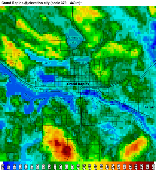
Below is the Elevation map of Grand Rapids, which displays elevation range with different colors. Scale of the first map is from 379 to 440 m (1243 to 1444 ft) with average elevation of 398.5 meters (=1307 ft) [note 1]
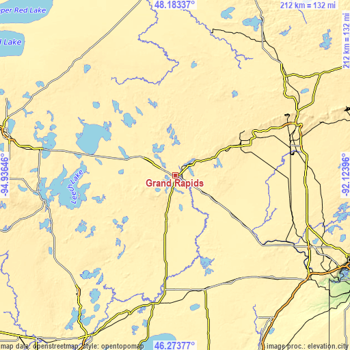
These maps also provides idea of topography and contour of this city, they are displayed at different zoom levels. More info about maps, scale and edge coordinates you can find below images.
| \ | Map #1 | Map #2 | Topo.Map |
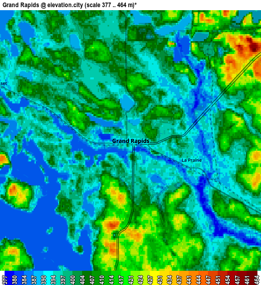
| Scale [m] | 379..440 m | 377..464 m | × |
| Scale [ft] | 1243..1444 ft | 1237..1522 ft | × |
| Average | 398.5 m = 1307 ft | 401.5 m = 1317 ft | × |
| Width | 6.64 km = 4.1 mi | 13.27 km = 8.2 mi | 212.3 km = 131.9 mi |
| Height | 6.64 km = 4.1 mi | 13.27 km = 8.2 mi | 212.3 km = 131.9 mi |
| ↑Max Latitude | 47.266999° | 47.296811° | 48.18337° |
| Latitude at center | 47.23717° | 47.23717° | 47.23717° |
| ↓Min Latitude | 47.207324° | 47.177462° | 46.27377° |
| ← Min Longitude | -93.574155° | -93.618101° | -94.93646° |
| Longitude center | -93.53021° | -93.53021° | -93.53021° |
| →Max Longitude | -93.486265° | -93.442319° | -92.12396° |
Nearby cities:
Cities around Grand Rapids sort by population:
• Hibbing elevation 454 m
49.4 km,  64°
64°
• Virginia 439 m
81.3 km,  66°
66°
• Chisholm 471 m
56.2 km, 60°
• Eveleth 486 m
78.7 km, 71°
• Mountain Iron 451 m
75.7 km, 64°
• Cohasset 392 m
7.4 km,  293°
293°
• Parkville 439 m
78.7 km, 65°
• Cross Lake 381 m
78 km,  214°
214°
• Aitkin 368 m
79.5 km,  189°
189°
• Coleraine 402 m
9.6 km,  53°
53°
• Keewatin 444 m
39 km, 62°
• Walker 402 m
81.3 km,  259°
259°
Multilingual:
 En español:
Grand Rapids elevación 392 m.
 En France:
Grand Rapids élévation 392 m.
 Auf Deutsch:
Grand Rapids höhe über dem Meeresspiegel ist 392 m.

Sources and notes:
- [note 1] Map square and city borders are not equal. Map elevation data is calculated only from area inside that square.
- [src 1] Elevation data from geonames database provided with same terms of usage.
- [src 2] The elevation map of Grand Rapids is generated using elevation data from NASA's 3 arcsec (90m) resolution SRTM data.
- [src 3] Base (background) map © OpenStreetMap contributors tiles are generated by Geofabrik and OpenTopoMap.
Copyright & License:
This Grand Rapids Elevation Map is licensed under CC BY-SA. You may reuse any part from this page, if you give a proper credit by linking to this URL:
 More info on terms of use page.