Glenwood elevation
Glenwood (Minnesota, Pope County), United States elevation is 352 meters and Glenwood elevation in feet is 1155 ft above sea level [src 1]. Glenwood is a seat of a second-order administrative division (feature code) with elevation that is 73 meters (240 ft) bigger than average city elevation in United States.
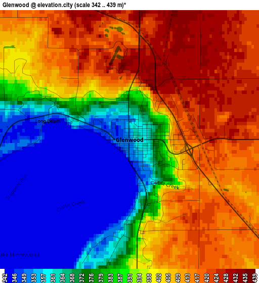
Below is the Elevation map of Glenwood, which displays elevation range with different colors. Scale of the first map is from 342 to 439 m (1122 to 1440 ft) with average elevation of 391.8 meters (=1285 ft) [note 1]
These maps also provides idea of topography and contour of this city, they are displayed at different zoom levels. More info about maps, scale and edge coordinates you can find below images.
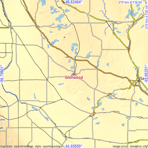
| \ | Map #1 | Topo.Map |
| Scale [m] | 342..439 m | × |
| Scale [ft] | 1122..1440 ft | × |
| Average | 391.8 m = 1285 ft | × |
| Width | 6.83 km = 4.2 mi | 218.6 km = 135.8 mi |
| Height | 6.83 km = 4.2 mi | 218.6 km = 135.8 mi |
| ↑Max Latitude | 45.680951° | 46.62464° |
| Latitude at center | 45.65024° | 45.65024° |
| ↓Min Latitude | 45.619512° | 44.65859° |
| ← Min Longitude | -95.433705° | -96.79601° |
| Longitude center | -95.38976° | -95.38976° |
| →Max Longitude | -95.345815° | -93.98351° |
Nearby cities:
Cities around Glenwood sort by population:
• Alexandria elevation 429 m
26.1 km,  2°
2°
• Morris 343 m
41.4 km,  260°
260°
• Sauk Centre 381 m
35.3 km,  74°
74°
• Melrose 367 m
45.3 km,  86°
86°
• Long Prairie 392 m
54.3 km,  48°
48°
• Benson 318 m
40.7 km,  203°
203°
• Osakis 414 m
30.3 km,  37°
37°
• New London 366 m
52.1 km,  138°
138°
• Starbuck 355 m
11.7 km,  250°
250°
• Spicer 357 m
58.2 km, 142°
• Elbow Lake 373 m
59.4 km,  310°
310°
• Parkers Prairie 447 m
56.1 km, 4°
Multilingual:
 En español:
Glenwood elevación 352 m.
 En France:
Glenwood élévation 352 m.
 Auf Deutsch:
Glenwood höhe über dem Meeresspiegel ist 352 m.

Sources and notes:
- [note 1] Map square and city borders are not equal. Map elevation data is calculated only from area inside that square.
- [src 1] Elevation data from geonames database provided with same terms of usage.
- [src 2] The elevation map of Glenwood is generated using elevation data from NASA's 3 arcsec (90m) resolution SRTM data.
- [src 3] Base (background) map © OpenStreetMap contributors tiles are generated by Geofabrik and OpenTopoMap.
Copyright & License:
This Glenwood Elevation Map is licensed under CC BY-SA. You may reuse any part from this page, if you give a proper credit by linking to this URL:
 More info on terms of use page.