Cologne elevation
Cologne (Minnesota, Carver County), United States elevation is 289 meters and Cologne elevation in feet is 948 ft above sea level [src 1]. Cologne is a populated place (feature code) with elevation that is 10 meters (33 ft) bigger than average city elevation in United States.
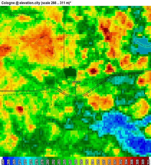
Below is the Elevation map of Cologne, which displays elevation range with different colors. Scale of the first map is from 266 to 311 m (873 to 1020 ft) with average elevation of 287.3 meters (=943 ft) [note 1]
These maps also provides idea of topography and contour of this city, they are displayed at different zoom levels. More info about maps, scale and edge coordinates you can find below images.
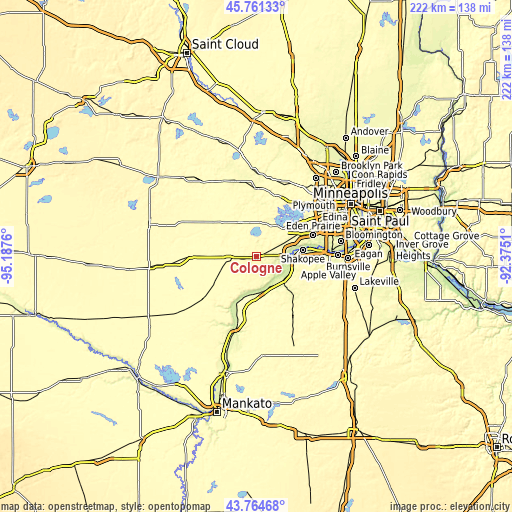
| \ | Map #1 | Topo.Map |
| Scale [m] | 266..311 m | × |
| Scale [ft] | 873..1020 ft | × |
| Average | 287.3 m = 943 ft | × |
| Width | 6.94 km = 4.3 mi | 222 km = 137.9 mi |
| Height | 6.94 km = 4.3 mi | 222 km = 137.9 mi |
| ↑Max Latitude | 44.802819° | 45.76133° |
| Latitude at center | 44.77163° | 44.77163° |
| ↓Min Latitude | 44.740424° | 43.76468° |
| ← Min Longitude | -93.825295° | -95.1876° |
| Longitude center | -93.78135° | -93.78135° |
| →Max Longitude | -93.737405° | -92.3751° |
Nearby cities:
Cities around Cologne sort by population:
• Chaska elevation 222 m
14.3 km,  82°
82°
• Waconia 306 m
8.8 km,  357°
357°
• Victoria 300 m
13.5 km,  44°
44°
• Minnetrista 284 m
19.2 km,  15°
15°
• Belle Plaine 259 m
16.6 km,  176°
176°
• Jordan 235 m
16.9 km,  133°
133°
• Carver 223 m
12.3 km,  94°
94°
• Norwood Young America 302 m
11.1 km,  271°
271°
• Saint Bonifacius 292 m
15.1 km,  10°
10°
• Mayer 294 m
15.1 km,  326°
326°
• Young America (historical) 313 m
10.5 km,  276°
276°
• Norwood (historical) 301 m
11.5 km, 268°
Multilingual:
 En español:
Cologne elevación 289 m.
 En France:
Cologne élévation 289 m.


Sources and notes:
- [note 1] Map square and city borders are not equal. Map elevation data is calculated only from area inside that square.
- [src 1] Elevation data from geonames database provided with same terms of usage.
- [src 2] The elevation map of Cologne is generated using elevation data from NASA's 3 arcsec (90m) resolution SRTM data.
- [src 3] Base (background) map © OpenStreetMap contributors tiles are generated by Geofabrik and OpenTopoMap.
Copyright & License:
This Cologne Elevation Map is licensed under CC BY-SA. You may reuse any part from this page, if you give a proper credit by linking to this URL:
 More info on terms of use page.