Springfield elevation
Springfield (Michigan, Calhoun County), United States elevation is 271 meters and Springfield elevation in feet is 889 ft above sea level [src 1]. Springfield is a populated place (feature code) with elevation that is 8 meters (26 ft) smaller than average city elevation in United States.
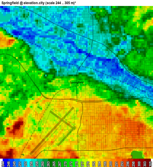
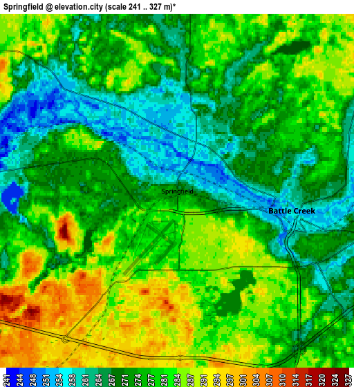
Below is the Elevation map of Springfield, which displays elevation range with different colors. Scale of the first map is from 244 to 305 m (801 to 1001 ft) with average elevation of 270.3 meters (=887 ft) [note 1]
These maps also provides idea of topography and contour of this city, they are displayed at different zoom levels. More info about maps, scale and edge coordinates you can find below images.
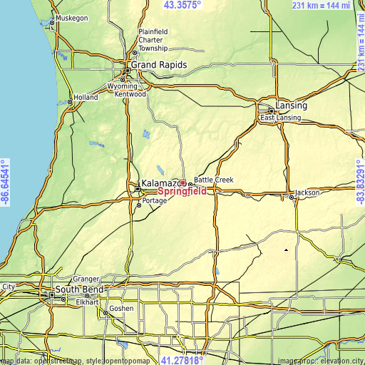
| \ | Map #1 | Map #2 | Topo.Map |
| Scale [m] | 244..305 m | 241..327 m | × |
| Scale [ft] | 801..1001 ft | 791..1073 ft | × |
| Average | 270.3 m = 887 ft | 276.3 m = 906 ft | × |
| Width | 7.22 km = 4.5 mi | 14.45 km = 9 mi | 231.2 km = 143.7 mi |
| Height | 7.22 km = 4.5 mi | 14.45 km = 9 mi | 231.2 km = 143.7 mi |
| ↑Max Latitude | 42.358911° | 42.391376° | 43.3575° |
| Latitude at center | 42.32643° | 42.32643° | 42.32643° |
| ↓Min Latitude | 42.293932° | 42.261417° | 41.27818° |
| ← Min Longitude | -85.283105° | -85.327051° | -86.64541° |
| Longitude center | -85.23916° | -85.23916° | -85.23916° |
| →Max Longitude | -85.195215° | -85.151269° | -83.83291° |
Nearby cities:
Cities around Springfield sort by population:
• Battle Creek elevation 254 m
5.1 km,  101°
101°
• Marshall 281 m
23.5 km, 104°
• Eastwood 266 m
25.7 km,  264°
264°
• Comstock Northwest 284 m
22.9 km,  268°
268°
• Level Park-Oak Park 281 m
4.8 km,  331°
331°
• Brownlee Park 270 m
8 km, 95°
• Galesburg 243 m
15.3 km,  254°
254°
• Stony Point 288 m
24.4 km,  320°
320°
• Bellevue 264 m
22.3 km,  54°
54°
• South Gull Lake 267 m
14.6 km,  297°
297°
• Lakeview 289 m
3.9 km,  143°
143°
• Athens 273 m
26.4 km,  179°
179°
Multilingual:
 En español:
Springfield elevación 271 m.
 En France:
Springfield élévation 271 m.
 Auf Deutsch:
Springfield höhe über dem Meeresspiegel ist 271 m.

Sources and notes:
- [note 1] Map square and city borders are not equal. Map elevation data is calculated only from area inside that square.
- [src 1] Elevation data from geonames database provided with same terms of usage.
- [src 2] The elevation map of Springfield is generated using elevation data from NASA's 3 arcsec (90m) resolution SRTM data.
- [src 3] Base (background) map © OpenStreetMap contributors tiles are generated by Geofabrik and OpenTopoMap.
Copyright & License:
This Springfield Elevation Map is licensed under CC BY-SA. You may reuse any part from this page, if you give a proper credit by linking to this URL:
 More info on terms of use page.