Mattawan elevation
Mattawan (Michigan, Van Buren County), United States elevation is 272 meters and Mattawan elevation in feet is 892 ft above sea level [src 1]. Mattawan is a populated place (feature code) with elevation that is 7 meters (23 ft) smaller than average city elevation in United States.
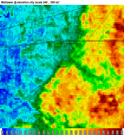
Below is the Elevation map of Mattawan, which displays elevation range with different colors. Scale of the first map is from 240 to 309 m (787 to 1014 ft) with average elevation of 268.3 meters (=880 ft) [note 1]
These maps also provides idea of topography and contour of this city, they are displayed at different zoom levels. More info about maps, scale and edge coordinates you can find below images.
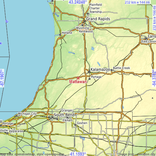
| \ | Map #1 | Topo.Map |
| Scale [m] | 240..309 m | × |
| Scale [ft] | 787..1014 ft | × |
| Average | 268.3 m = 880 ft | × |
| Width | 7.24 km = 4.5 mi | 231.6 km = 143.9 mi |
| Height | 7.24 km = 4.5 mi | 231.6 km = 143.9 mi |
| ↑Max Latitude | 42.242022° | 43.24248° |
| Latitude at center | 42.20948° | 42.20948° |
| ↓Min Latitude | 42.176922° | 41.1593° |
| ← Min Longitude | -85.828395° | -87.1907° |
| Longitude center | -85.78445° | -85.78445° |
| →Max Longitude | -85.740505° | -84.3782° |
Nearby cities:
Cities around Mattawan sort by population:
• Kalamazoo elevation 242 m
18.6 km,  60°
60°
• Portage 273 m
16.9 km,  93°
93°
• Westwood 287 m
16.2 km,  50°
50°
• Eastwood 266 m
21.9 km, 61°
• Comstock Northwest 284 m
25.3 km, 60°
• Paw Paw 223 m
8.8 km,  276°
276°
• Vicksburg 262 m
23 km,  115°
115°
• Lawton 243 m
7 km,  227°
227°
• Parchment 238 m
22 km, 53°
• Decatur 242 m
19.3 km, 234°
• Schoolcraft 270 m
16.1 km,  131°
131°
• Marcellus 275 m
20.6 km,  187°
187°
Multilingual:
 En español:
Mattawan elevación 272 m.
 En France:
Mattawan élévation 272 m.
 Auf Deutsch:
Mattawan höhe über dem Meeresspiegel ist 272 m.

Sources and notes:
- [note 1] Map square and city borders are not equal. Map elevation data is calculated only from area inside that square.
- [src 1] Elevation data from geonames database provided with same terms of usage.
- [src 2] The elevation map of Mattawan is generated using elevation data from NASA's 3 arcsec (90m) resolution SRTM data.
- [src 3] Base (background) map © OpenStreetMap contributors tiles are generated by Geofabrik and OpenTopoMap.
Copyright & License:
This Mattawan Elevation Map is licensed under CC BY-SA. You may reuse any part from this page, if you give a proper credit by linking to this URL:
 More info on terms of use page.