Grosse Ile elevation
Grosse Ile (Michigan, Wayne County), United States elevation is 181 meters and Grosse Ile elevation in feet is 594 ft above sea level [src 1]. Grosse Ile is a populated place (feature code) with elevation that is 98 meters (322 ft) smaller than average city elevation in United States.
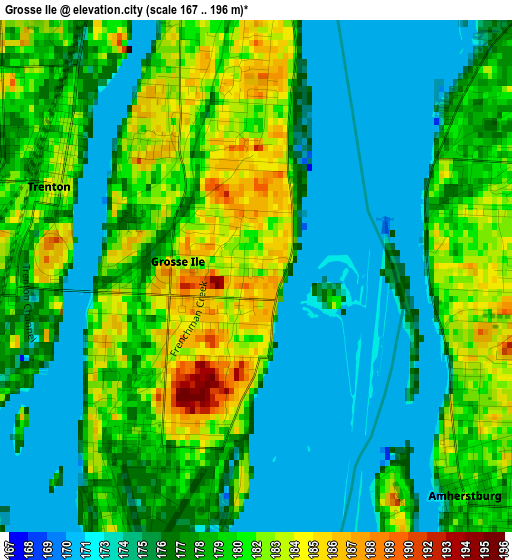
Below is the Elevation map of Grosse Ile, which displays elevation range with different colors. Scale of the first map is from 167 to 196 m (548 to 643 ft) with average elevation of 178 meters (=584 ft) [note 1]
These maps also provides idea of topography and contour of this city, they are displayed at different zoom levels. More info about maps, scale and edge coordinates you can find below images.
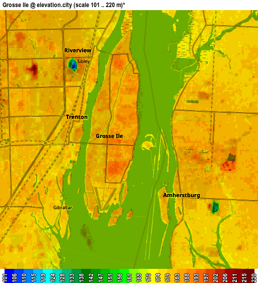
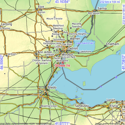
| \ | Map #1 | Map #2 | Topo.Map |
| Scale [m] | 167..196 m | 101..220 m | × |
| Scale [ft] | 548..643 ft | 331..722 ft | × |
| Average | 178 m = 584 ft | 178 m = 584 ft | × |
| Width | 7.25 km = 4.5 mi | 14.5 km = 9 mi | 231.9 km = 144.1 mi |
| Height | 7.25 km = 4.5 mi | 14.5 km = 9 mi | 231.9 km = 144.1 mi |
| ↑Max Latitude | 42.161793° | 42.194359° | 43.16354° |
| Latitude at center | 42.12921° | 42.12921° | 42.12921° |
| ↓Min Latitude | 42.09661° | 42.063994° | 41.07771° |
| ← Min Longitude | -83.188315° | -83.232261° | -84.55062° |
| Longitude center | -83.14437° | -83.14437° | -83.14437° |
| →Max Longitude | -83.100425° | -83.056479° | -81.73812° |
Nearby cities:
Cities around Grosse Ile sort by population:
• Lincoln Park elevation 179 m
13.8 km,  348°
348°
• Southgate 184 m
10.3 km,  336°
336°
• Allen Park 182 m
15.3 km, 338°
• Wyandotte 177 m
9.5 km,  357°
357°
• Trenton 182 m
3 km,  292°
292°
• Woodhaven 181 m
8.1 km,  277°
277°
• Riverview 185 m
5.8 km,  330°
330°
• Flat Rock 182 m
12.7 km,  253°
253°
• Ecorse 177 m
12.8 km, 359°
• Gibraltar 176 m
5.3 km,  224°
224°
• Rockwood 178 m
10.6 km,  232°
232°
• South Rockwood 181 m
12.1 km, 232°
Multilingual:
 En español:
Grosse Ile elevación 181 m.
 En France:
Grosse Ile élévation 181 m.
 Auf Deutsch:
Grosse Ile höhe über dem Meeresspiegel ist 181 m.

Sources and notes:
- [note 1] Map square and city borders are not equal. Map elevation data is calculated only from area inside that square.
- [src 1] Elevation data from geonames database provided with same terms of usage.
- [src 2] The elevation map of Grosse Ile is generated using elevation data from NASA's 3 arcsec (90m) resolution SRTM data.
- [src 3] Base (background) map © OpenStreetMap contributors tiles are generated by Geofabrik and OpenTopoMap.
Copyright & License:
This Grosse Ile Elevation Map is licensed under CC BY-SA. You may reuse any part from this page, if you give a proper credit by linking to this URL:
 More info on terms of use page.