Grand Rapids elevation
Grand Rapids (Michigan, Kent County), United States elevation is 205 meters and Grand Rapids elevation in feet is 673 ft above sea level [src 1]. Grand Rapids is a seat of a second-order administrative division (feature code) with elevation that is 74 meters (243 ft) smaller than average city elevation in United States.
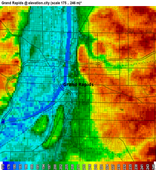
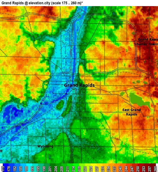
Below is the Elevation map of Grand Rapids, which displays elevation range with different colors. Scale of the first map is from 175 to 246 m (574 to 807 ft) with average elevation of 209.5 meters (=687 ft) [note 1]
These maps also provides idea of topography and contour of this city, they are displayed at different zoom levels. More info about maps, scale and edge coordinates you can find below images.
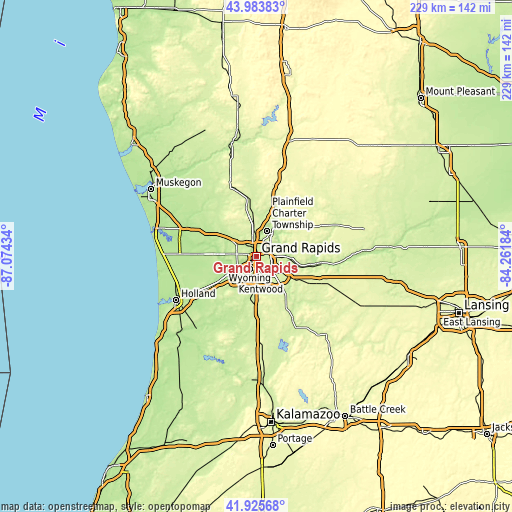
| \ | Map #1 | Map #2 | Topo.Map |
| Scale [m] | 175..246 m | 175..260 m | × |
| Scale [ft] | 574..807 ft | 574..853 ft | × |
| Average | 209.5 m = 687 ft | 216.9 m = 712 ft | × |
| Width | 7.15 km = 4.4 mi | 14.3 km = 8.9 mi | 228.8 km = 142.2 mi |
| Height | 7.15 km = 4.4 mi | 14.3 km = 8.9 mi | 228.8 km = 142.2 mi |
| ↑Max Latitude | 42.99551° | 43.027644° | 43.98383° |
| Latitude at center | 42.96336° | 42.96336° | 42.96336° |
| ↓Min Latitude | 42.931193° | 42.899009° | 41.92568° |
| ← Min Longitude | -85.712035° | -85.755981° | -87.07434° |
| Longitude center | -85.66809° | -85.66809° | -85.66809° |
| →Max Longitude | -85.624145° | -85.580199° | -84.26184° |
Nearby cities:
Cities around Grand Rapids sort by population:
• Wyoming elevation 199 m
6.3 km,  208°
208°
• Kentwood 212 m
10.6 km,  169°
169°
• Forest Hills 198 m
14.5 km,  91°
91°
• Walker 228 m
9.2 km,  297°
297°
• Jenison 186 m
11.9 km,  238°
238°
• Grandville 185 m
9.8 km,  232°
232°
• Northview 229 m
10.7 km,  30°
30°
• Cutlerville 208 m
13.6 km,  178°
178°
• East Grand Rapids 232 m
5.3 km,  117°
117°
• Comstock Park 200 m
8.4 km,  358°
358°
• Hudsonville 196 m
19.1 km, 237°
• Byron Center 228 m
17.4 km,  194°
194°
Multilingual:
 En español:
Grand Rapids elevación 205 m.
 En France:
Grand Rapids élévation 205 m.
 Auf Deutsch:
Grand Rapids höhe über dem Meeresspiegel ist 205 m.

Sources and notes:
- [note 1] Map square and city borders are not equal. Map elevation data is calculated only from area inside that square.
- [src 1] Elevation data from geonames database provided with same terms of usage.
- [src 2] The elevation map of Grand Rapids is generated using elevation data from NASA's 3 arcsec (90m) resolution SRTM data.
- [src 3] Base (background) map © OpenStreetMap contributors tiles are generated by Geofabrik and OpenTopoMap.
Copyright & License:
This Grand Rapids Elevation Map is licensed under CC BY-SA. You may reuse any part from this page, if you give a proper credit by linking to this URL:
 More info on terms of use page.