Grand Haven elevation
Grand Haven (Michigan, Ottawa County), United States elevation is 184 meters and Grand Haven elevation in feet is 604 ft above sea level [src 1]. Grand Haven is a seat of a second-order administrative division (feature code) with elevation that is 95 meters (312 ft) smaller than average city elevation in United States.
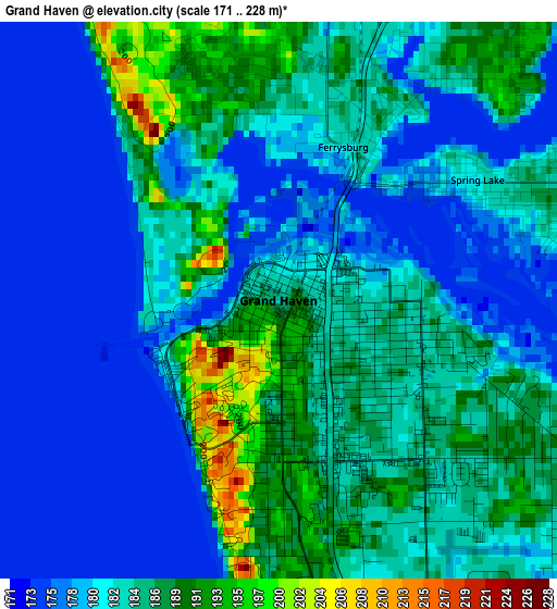
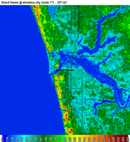
Below is the Elevation map of Grand Haven, which displays elevation range with different colors. Scale of the first map is from 171 to 228 m (561 to 748 ft) with average elevation of 182.7 meters (=599 ft) [note 1]
These maps also provides idea of topography and contour of this city, they are displayed at different zoom levels. More info about maps, scale and edge coordinates you can find below images.
| \ | Map #1 | Map #2 | Topo.Map |
| Scale [m] | 171..228 m | 171..237 m | × |
| Scale [ft] | 561..748 ft | 561..778 ft | × |
| Average | 182.7 m = 599 ft | 183.1 m = 601 ft | × |
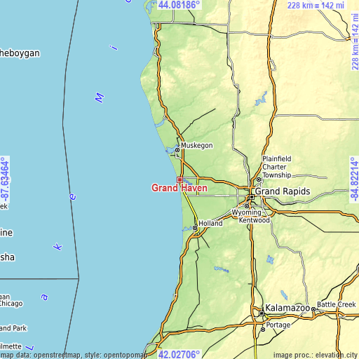
| Width | 7.14 km = 4.4 mi | 14.28 km = 8.9 mi | 228.5 km = 142 mi |
| Height | 7.14 km = 4.4 mi | 14.28 km = 8.9 mi | 228.5 km = 142 mi |
| ↑Max Latitude | 43.095168° | 43.127249° | 44.08186° |
| Latitude at center | 43.06307° | 43.06307° | 43.06307° |
| ↓Min Latitude | 43.030955° | 42.998823° | 42.02706° |
| ← Min Longitude | -86.272335° | -86.316281° | -87.63464° |
| Longitude center | -86.22839° | -86.22839° | -86.22839° |
| →Max Longitude | -86.184445° | -86.140499° | -84.82214° |
Nearby cities:
Cities around Grand Haven sort by population:
• Muskegon elevation 192 m
19.1 km,  355°
355°
• Norton Shores 191 m
12.1 km,  346°
346°
• Allendale 201 m
24.5 km,  114°
114°
• Muskegon Heights 194 m
15.4 km, 356°
• Coopersville 196 m
23.9 km,  89°
89°
• Wolf Lake 208 m
23.4 km,  24°
24°
• Roosevelt Park 192 m
15.2 km, 346°
• North Muskegon 190 m
21.7 km, 351°
• Ferrysburg 186 m
2.5 km, 15°
• Spring Lake 182 m
3 km,  58°
58°
• Ravenna 202 m
27.5 km, 59°
• Fruitport 192 m
9.7 km,  37°
37°
Multilingual:
 En español:
Grand Haven elevación 184 m.
 En France:
Grand Haven élévation 184 m.
 Auf Deutsch:
Grand Haven höhe über dem Meeresspiegel ist 184 m.

Sources and notes:
- [note 1] Map square and city borders are not equal. Map elevation data is calculated only from area inside that square.
- [src 1] Elevation data from geonames database provided with same terms of usage.
- [src 2] The elevation map of Grand Haven is generated using elevation data from NASA's 3 arcsec (90m) resolution SRTM data.
- [src 3] Base (background) map © OpenStreetMap contributors tiles are generated by Geofabrik and OpenTopoMap.
Copyright & License:
This Grand Haven Elevation Map is licensed under CC BY-SA. You may reuse any part from this page, if you give a proper credit by linking to this URL:
 More info on terms of use page.