Sangerville elevation
Sangerville (Maine, Piscataquis County), United States elevation is 133 meters and Sangerville elevation in feet is 436 ft above sea level [src 1]. Sangerville is a populated place (feature code) with elevation that is 146 meters (479 ft) smaller than average city elevation in United States.
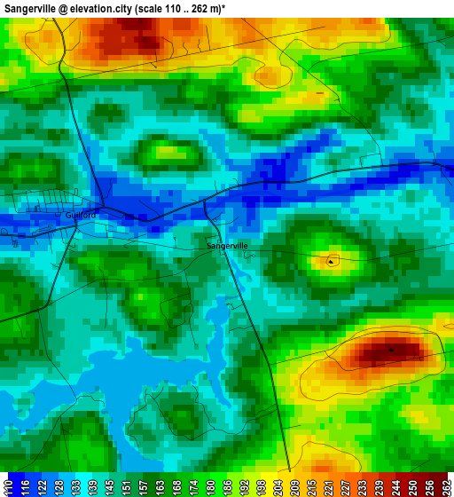
Below is the Elevation map of Sangerville, which displays elevation range with different colors. Scale of the first map is from 110 to 262 m (361 to 860 ft) with average elevation of 161.5 meters (=530 ft) [note 1]
These maps also provides idea of topography and contour of this city, they are displayed at different zoom levels. More info about maps, scale and edge coordinates you can find below images.
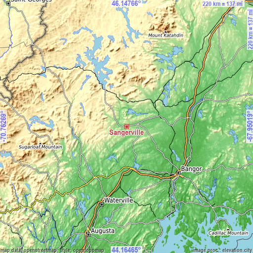
| \ | Map #1 | Topo.Map |
| Scale [m] | 110..262 m | × |
| Scale [ft] | 361..860 ft | × |
| Average | 161.5 m = 530 ft | × |
| Width | 6.89 km = 4.3 mi | 220.5 km = 137 mi |
| Height | 6.89 km = 4.3 mi | 220.5 km = 137 mi |
| ↑Max Latitude | 45.195756° | 46.14766° |
| Latitude at center | 45.16478° | 45.16478° |
| ↓Min Latitude | 45.133787° | 44.16465° |
| ← Min Longitude | -69.400385° | -70.76269° |
| Longitude center | -69.35644° | -69.35644° |
| →Max Longitude | -69.312495° | -67.95019° |
Nearby cities:
Cities around Sangerville sort by population:
• Dover-Foxcroft elevation 116 m
10.4 km,  78°
78°
• Corinna 75 m
28.1 km,  164°
164°
• Dexter 128 m
16.5 km, 161°
• Palmyra 93 m
35.4 km,  180°
180°
• Saint Albans 82 m
28.6 km,  188°
188°
• Milo 105 m
30.7 km,  71°
71°
• Newport 66 m
37.2 km,  169°
169°
• Charleston 149 m
26.3 km,  109°
109°
• Brownville 109 m
29.8 km,  57°
57°
• Bradford 72 m
34.6 km, 108°
• Garland 110 m
20.8 km,  132°
132°
• Stetson 69 m
34.7 km,  151°
151°
Multilingual:
 En español:
Sangerville elevación 133 m.
 En France:
Sangerville élévation 133 m.
 Auf Deutsch:
Sangerville höhe über dem Meeresspiegel ist 133 m.

Sources and notes:
- [note 1] Map square and city borders are not equal. Map elevation data is calculated only from area inside that square.
- [src 1] Elevation data from geonames database provided with same terms of usage.
- [src 2] The elevation map of Sangerville is generated using elevation data from NASA's 3 arcsec (90m) resolution SRTM data.
- [src 3] Base (background) map © OpenStreetMap contributors tiles are generated by Geofabrik and OpenTopoMap.
Copyright & License:
This Sangerville Elevation Map is licensed under CC BY-SA. You may reuse any part from this page, if you give a proper credit by linking to this URL:
 More info on terms of use page.