Lovell elevation
Lovell (Maine, Oxford County), United States elevation is 130 meters and Lovell elevation in feet is 427 ft above sea level [src 1]. Lovell is a populated place (feature code) with elevation that is 149 meters (489 ft) smaller than average city elevation in United States.
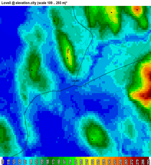
Below is the Elevation map of Lovell, which displays elevation range with different colors. Scale of the first map is from 109 to 293 m (358 to 961 ft) with average elevation of 142.2 meters (=467 ft) [note 1]
These maps also provides idea of topography and contour of this city, they are displayed at different zoom levels. More info about maps, scale and edge coordinates you can find below images.
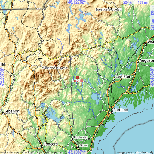
| \ | Map #1 | Topo.Map |
| Scale [m] | 109..293 m | × |
| Scale [ft] | 358..961 ft | × |
| Average | 142.2 m = 467 ft | × |
| Width | 7.01 km = 4.4 mi | 224.5 km = 139.5 mi |
| Height | 7.01 km = 4.4 mi | 224.5 km = 139.5 mi |
| ↑Max Latitude | 44.158276° | 45.12752° |
| Latitude at center | 44.12674° | 44.12674° |
| ↓Min Latitude | 44.095188° | 43.10871° |
| ← Min Longitude | -70.935675° | -72.29798° |
| Longitude center | -70.89173° | -70.89173° |
| →Max Longitude | -70.847785° | -69.48548° |
Nearby cities:
Cities around Lovell sort by population:
• Norway elevation 121 m
29.3 km,  70°
70°
• Bethel 224 m
31.9 km,  14°
14°
• Harrison 89 m
17.1 km,  96°
96°
• North Conway 163 m
20.6 km,  246°
246°
• South Paris 118 m
32 km, 70°
• Bridgton 136 m
16.4 km,  119°
119°
• Conway 142 m
24.6 km,  228°
228°
• Fryeburg 131 m
14.2 km,  210°
210°
• Hiram 110 m
28.5 km,  165°
165°
• Brownfield 130 m
21 km,  183°
183°
• Oxford 103 m
31.8 km,  88°
88°
• Denmark 161 m
18.8 km,  157°
157°
Multilingual:
 En español:
Lovell elevación 130 m.
 En France:
Lovell élévation 130 m.


Sources and notes:
- [note 1] Map square and city borders are not equal. Map elevation data is calculated only from area inside that square.
- [src 1] Elevation data from geonames database provided with same terms of usage.
- [src 2] The elevation map of Lovell is generated using elevation data from NASA's 3 arcsec (90m) resolution SRTM data.
- [src 3] Base (background) map © OpenStreetMap contributors tiles are generated by Geofabrik and OpenTopoMap.
Copyright & License:
This Lovell Elevation Map is licensed under CC BY-SA. You may reuse any part from this page, if you give a proper credit by linking to this URL:
 More info on terms of use page.