Woburn elevation
Woburn (Massachusetts, Middlesex County), United States elevation is 34 meters and Woburn elevation in feet is 112 ft above sea level [src 1]. Woburn is a populated place (feature code) with elevation that is 245 meters (804 ft) smaller than average city elevation in United States.
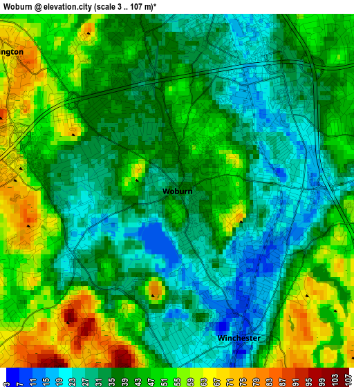
Below is the Elevation map of Woburn, which displays elevation range with different colors. Scale of the first map is from 3 to 107 m (10 to 351 ft) with average elevation of 40.7 meters (=134 ft) [note 1]
These maps also provides idea of topography and contour of this city, they are displayed at different zoom levels. More info about maps, scale and edge coordinates you can find below images.
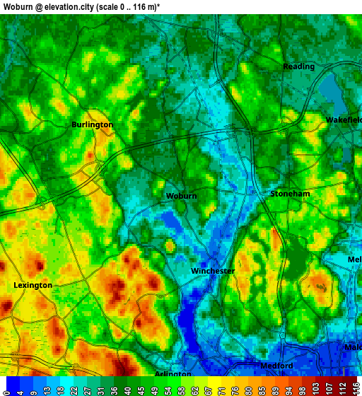
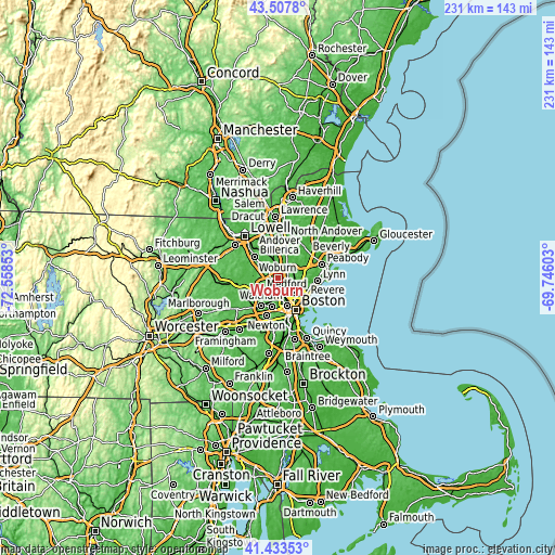
| \ | Map #1 | Map #2 | Topo.Map |
| Scale [m] | 3..107 m | 0..116 m | × |
| Scale [ft] | 10..351 ft | 0..381 ft | × |
| Average | 40.7 m = 134 ft | 45.2 m = 148 ft | × |
| Width | 7.21 km = 4.5 mi | 14.41 km = 9 mi | 230.6 km = 143.3 mi |
| Height | 7.21 km = 4.5 mi | 14.41 km = 9 mi | 230.6 km = 143.3 mi |
| ↑Max Latitude | 42.511662° | 42.544048° | 43.5078° |
| Latitude at center | 42.47926° | 42.47926° | 42.47926° |
| ↓Min Latitude | 42.446841° | 42.414405° | 41.43353° |
| ← Min Longitude | -71.196225° | -71.240171° | -72.55853° |
| Longitude center | -71.15228° | -71.15228° | -71.15228° |
| →Max Longitude | -71.108335° | -71.064389° | -69.74603° |
Nearby cities:
Cities around Woburn sort by population:
• Malden elevation 6 m
9.3 km,  130°
130°
• Medford 12 m
7.8 km,  150°
150°
• Arlington 25 m
7.1 km,  182°
182°
• Lexington 69 m
6.9 km,  239°
239°
• Melrose 21 m
7.4 km,  108°
108°
• Wakefield 35 m
7.2 km,  65°
65°
• Reading 30 m
7 km,  42°
42°
• Burlington 68 m
4.5 km,  308°
308°
• Wilmington 31 m
7.7 km,  346°
346°
• Stoneham 50 m
4.3 km,  88°
88°
• Winchester 10 m
3.2 km,  157°
157°
• Pinehurst 35 m
8.3 km, 311°
Multilingual:
 En español:
Woburn elevación 34 m.
 En France:
Woburn élévation 34 m.


Sources and notes:
- [note 1] Map square and city borders are not equal. Map elevation data is calculated only from area inside that square.
- [src 1] Elevation data from geonames database provided with same terms of usage.
- [src 2] The elevation map of Woburn is generated using elevation data from NASA's 3 arcsec (90m) resolution SRTM data.
- [src 3] Base (background) map © OpenStreetMap contributors tiles are generated by Geofabrik and OpenTopoMap.
Copyright & License:
This Woburn Elevation Map is licensed under CC BY-SA. You may reuse any part from this page, if you give a proper credit by linking to this URL:
 More info on terms of use page.