Winthrop elevation
Winthrop (Massachusetts, Suffolk County), United States elevation is 15 meters and Winthrop elevation in feet is 49 ft above sea level [src 1]. Winthrop is a populated place (feature code) with elevation that is 264 meters (866 ft) smaller than average city elevation in United States.
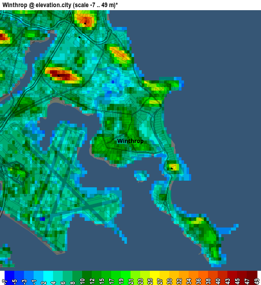
Below is the Elevation map of Winthrop, which displays elevation range with different colors. Scale of the first map is from -7 to 49 m (-23 to 161 ft) with average elevation of 8.1 meters (=27 ft) [note 1]
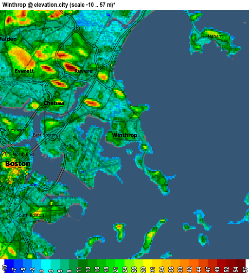
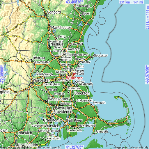
These maps also provides idea of topography and contour of this city, they are displayed at different zoom levels. More info about maps, scale and edge coordinates you can find below images.
| \ | Map #1 | Map #2 | Topo.Map |
| Scale [m] | -7..49 m | -10..57 m | × |
| Scale [ft] | -23..161 ft | -33..187 ft | × |
| Average | 8.1 m = 27 ft | 10.7 m = 35 ft | × |
| Width | 7.22 km = 4.5 mi | 14.44 km = 9 mi | 231 km = 143.5 mi |
| Height | 7.22 km = 4.5 mi | 14.44 km = 9 mi | 231 km = 143.5 mi |
| ↑Max Latitude | 42.407556° | 42.439995° | 43.40536° |
| Latitude at center | 42.3751° | 42.3751° | 42.3751° |
| ↓Min Latitude | 42.342627° | 42.310137° | 41.32765° |
| ← Min Longitude | -71.026775° | -71.070721° | -72.38908° |
| Longitude center | -70.98283° | -70.98283° | -70.98283° |
| →Max Longitude | -70.938885° | -70.894939° | -69.57658° |
Nearby cities:
Cities around Winthrop sort by population:
• Boston elevation 38 m
6.6 km,  253°
253°
• South Boston 20 m
7.2 km,  229°
229°
• Cambridge 13 m
10.1 km,  270°
270°
• Lynn 17 m
10.6 km,  15°
15°
• Somerville 31 m
9.7 km,  278°
278°
• Malden 6 m
8.8 km,  309°
309°
• Revere 8 m
4.4 km,  327°
327°
• Everett 22 m
6.9 km,  302°
302°
• Chelsea 18 m
4.5 km,  294°
294°
• Saugus 11 m
10.2 km,  347°
347°
• Hull 20 m
10.2 km,  142°
142°
• Nahant 29 m
7.8 km,  42°
42°
Multilingual:
 En español:
Winthrop elevación 15 m.
 En France:
Winthrop élévation 15 m.


Sources and notes:
- [note 1] Map square and city borders are not equal. Map elevation data is calculated only from area inside that square.
- [src 1] Elevation data from geonames database provided with same terms of usage.
- [src 2] The elevation map of Winthrop is generated using elevation data from NASA's 3 arcsec (90m) resolution SRTM data.
- [src 3] Base (background) map © OpenStreetMap contributors tiles are generated by Geofabrik and OpenTopoMap.
Copyright & License:
This Winthrop Elevation Map is licensed under CC BY-SA. You may reuse any part from this page, if you give a proper credit by linking to this URL:
 More info on terms of use page.