Smith Mills elevation
Smith Mills (Massachusetts, Bristol County), United States elevation is -1 meters and Smith Mills elevation in feet is -3 ft above sea level [src 1]. Smith Mills is a populated place (feature code) with elevation that is 280 meters (919 ft) smaller than average city elevation in United States.
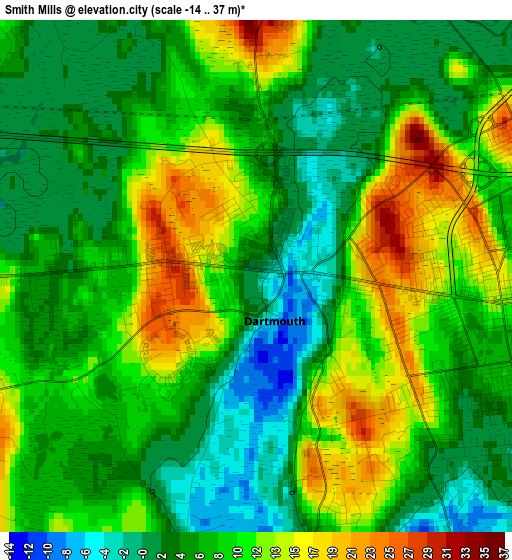
Below is the Elevation map of Smith Mills, which displays elevation range with different colors. Scale of the first map is from -14 to 37 m (-46 to 121 ft) with average elevation of 7.4 meters (=24 ft) [note 1]
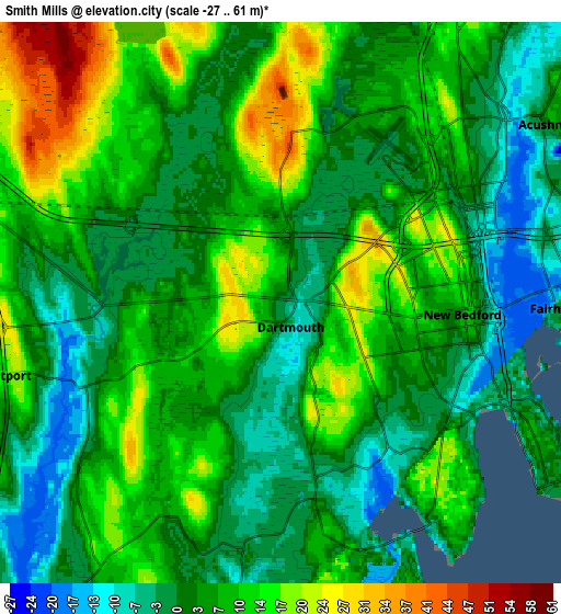
These maps also provides idea of topography and contour of this city, they are displayed at different zoom levels. More info about maps, scale and edge coordinates you can find below images.
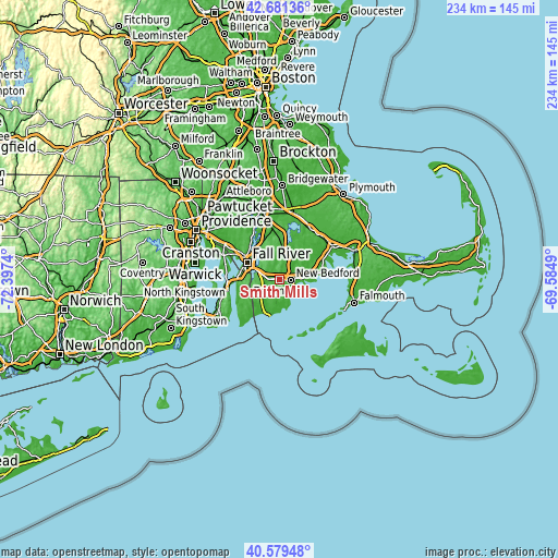
| \ | Map #1 | Map #2 | Topo.Map |
| Scale [m] | -14..37 m | -27..61 m | × |
| Scale [ft] | -46..121 ft | -89..200 ft | × |
| Average | 7.4 m = 24 ft | 6.2 m = 20 ft | × |
| Width | 7.3 km = 4.5 mi | 14.61 km = 9.1 mi | 233.7 km = 145.2 mi |
| Height | 7.3 km = 4.5 mi | 14.61 km = 9.1 mi | 233.7 km = 145.2 mi |
| ↑Max Latitude | 41.671824° | 41.704641° | 42.68136° |
| Latitude at center | 41.63899° | 41.63899° | 41.63899° |
| ↓Min Latitude | 41.606139° | 41.573272° | 40.57948° |
| ← Min Longitude | -71.035095° | -71.079041° | -72.3974° |
| Longitude center | -70.99115° | -70.99115° | -70.99115° |
| →Max Longitude | -70.947205° | -70.903259° | -69.5849° |
Nearby cities:
Cities around Smith Mills sort by population:
• New Bedford elevation 15 m
5.3 km,  94°
94°
• Fall River 12 m
15.3 km,  297°
297°
• Fairhaven 3 m
7.3 km, 91°
• Head of Westport -15 m
6.2 km,  251°
251°
• Acushnet 2 m
8.3 km,  56°
56°
• Freetown 29 m
14.6 km,  346°
346°
• Mattapoisett -1 m
14.7 km,  81°
81°
• Bliss Corner 0 m
5.3 km,  124°
124°
• Rochester -10 m
17.6 km,  54°
54°
• North Westport 19 m
8.4 km,  286°
286°
• Acushnet Center 6 m
8.7 km, 53°
• Mattapoisett Center 30 m
15.6 km, 78°
Multilingual:
 En español:
Smith Mills elevación -1 m.
 En France:
Smith Mills élévation -1 m.
 Auf Deutsch:
Smith Mills höhe über dem Meeresspiegel ist -1 m.

Sources and notes:
- [note 1] Map square and city borders are not equal. Map elevation data is calculated only from area inside that square.
- [src 1] Elevation data from geonames database provided with same terms of usage.
- [src 2] The elevation map of Smith Mills is generated using elevation data from NASA's 3 arcsec (90m) resolution SRTM data.
- [src 3] Base (background) map © OpenStreetMap contributors tiles are generated by Geofabrik and OpenTopoMap.
Copyright & License:
This Smith Mills Elevation Map is licensed under CC BY-SA. You may reuse any part from this page, if you give a proper credit by linking to this URL:
 More info on terms of use page.