Norfolk elevation
Norfolk (Massachusetts, Norfolk County), United States elevation is 67 meters and Norfolk elevation in feet is 220 ft above sea level [src 1]. Norfolk is a populated place (feature code) with elevation that is 212 meters (696 ft) smaller than average city elevation in United States.
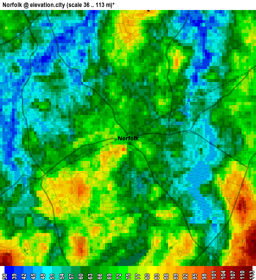
Below is the Elevation map of Norfolk, which displays elevation range with different colors. Scale of the first map is from 36 to 113 m (118 to 371 ft) with average elevation of 64.1 meters (=210 ft) [note 1]
These maps also provides idea of topography and contour of this city, they are displayed at different zoom levels. More info about maps, scale and edge coordinates you can find below images.
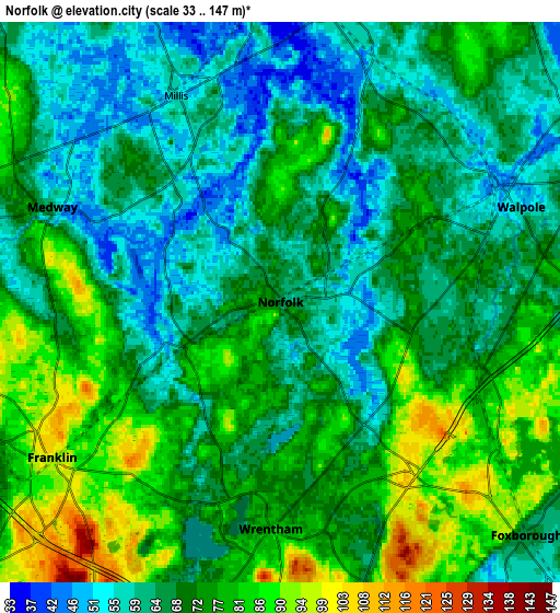
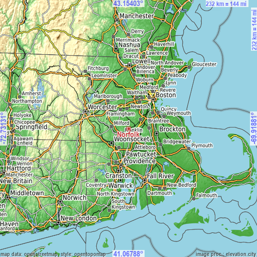
| \ | Map #1 | Map #2 | Topo.Map |
| Scale [m] | 36..113 m | 33..147 m | × |
| Scale [ft] | 118..371 ft | 108..482 ft | × |
| Average | 64.1 m = 210 ft | 70.5 m = 231 ft | × |
| Width | 7.25 km = 4.5 mi | 14.5 km = 9 mi | 232 km = 144.2 mi |
| Height | 7.25 km = 4.5 mi | 14.5 km = 9 mi | 231.9 km = 144.1 mi |
| ↑Max Latitude | 42.152128° | 42.184699° | 43.15403° |
| Latitude at center | 42.11954° | 42.11954° | 42.11954° |
| ↓Min Latitude | 42.086935° | 42.054314° | 41.06788° |
| ← Min Longitude | -71.369005° | -71.412951° | -72.73131° |
| Longitude center | -71.32506° | -71.32506° | -71.32506° |
| →Max Longitude | -71.281115° | -71.237169° | -69.91881° |
Nearby cities:
Cities around Norfolk sort by population:
• Franklin elevation 94 m
7.1 km,  235°
235°
• Holliston 62 m
12.1 km,  317°
317°
• Medway 61 m
6.4 km,  292°
292°
• Wrentham 77 m
5.9 km,  182°
182°
• Millis 58 m
6 km,  333°
333°
• Plainville 68 m
12.8 km, 182°
• Medfield 57 m
7.7 km,  11°
11°
• Walpole 50 m
6.7 km,  68°
68°
• Sharon 96 m
12.1 km,  87°
87°
• Foxborough 66 m
8.8 km,  133°
133°
• Bellingham 95 m
12.9 km,  253°
253°
• Millis-Clicquot 54 m
5.6 km, 334°
Multilingual:
 En español:
Norfolk elevación 67 m.
 En France:
Norfolk élévation 67 m.


Sources and notes:
- [note 1] Map square and city borders are not equal. Map elevation data is calculated only from area inside that square.
- [src 1] Elevation data from geonames database provided with same terms of usage.
- [src 2] The elevation map of Norfolk is generated using elevation data from NASA's 3 arcsec (90m) resolution SRTM data.
- [src 3] Base (background) map © OpenStreetMap contributors tiles are generated by Geofabrik and OpenTopoMap.
Copyright & License:
This Norfolk Elevation Map is licensed under CC BY-SA. You may reuse any part from this page, if you give a proper credit by linking to this URL:
 More info on terms of use page.