Milford elevation
Milford (Massachusetts, Worcester County), United States elevation is 79 meters and Milford elevation in feet is 259 ft above sea level [src 1]. Milford is a populated place (feature code) with elevation that is 200 meters (656 ft) smaller than average city elevation in United States.
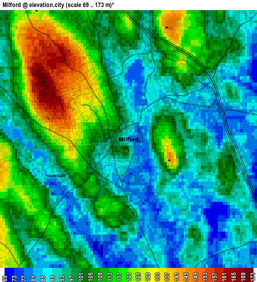
Below is the Elevation map of Milford, which displays elevation range with different colors. Scale of the first map is from 69 to 173 m (226 to 568 ft) with average elevation of 101.1 meters (=332 ft) [note 1]
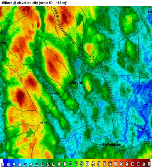
These maps also provides idea of topography and contour of this city, they are displayed at different zoom levels. More info about maps, scale and edge coordinates you can find below images.
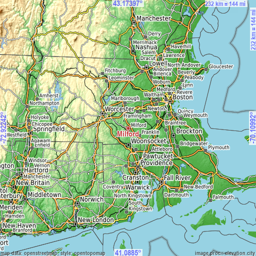
| \ | Map #1 | Map #2 | Topo.Map |
| Scale [m] | 69..173 m | 50..186 m | × |
| Scale [ft] | 226..568 ft | 164..610 ft | × |
| Average | 101.1 m = 332 ft | 103.1 m = 338 ft | × |
| Width | 7.25 km = 4.5 mi | 14.49 km = 9 mi | 231.9 km = 144.1 mi |
| Height | 7.25 km = 4.5 mi | 14.49 km = 9 mi | 231.9 km = 144.1 mi |
| ↑Max Latitude | 42.172397° | 42.204958° | 43.17397° |
| Latitude at center | 42.13982° | 42.13982° | 42.13982° |
| ↓Min Latitude | 42.107226° | 42.074615° | 41.0885° |
| ← Min Longitude | -71.560115° | -71.604061° | -72.92242° |
| Longitude center | -71.51617° | -71.51617° | -71.51617° |
| →Max Longitude | -71.472225° | -71.428279° | -70.10992° |
Nearby cities:
Cities around Milford sort by population:
• Franklin elevation 94 m
11.7 km,  122°
122°
• Northbridge 85 m
11.1 km,  276°
276°
• Holliston 62 m
10.1 km,  48°
48°
• Medway 61 m
9.8 km,  88°
88°
• Uxbridge 76 m
11.6 km,  233°
233°
• Millis 58 m
13.4 km,  76°
76°
• Whitinsville 97 m
12.8 km,  255°
255°
• Mendon 112 m
4.8 km,  218°
218°
• Bellingham 95 m
6.8 km,  149°
149°
• Hopedale 88 m
2.3 km,  243°
243°
• Upton 92 m
8.1 km,  298°
298°
• Hopkinton 135 m
9.9 km,  356°
356°
Multilingual:
 En español:
Milford elevación 79 m.
 En France:
Milford élévation 79 m.


Sources and notes:
- [note 1] Map square and city borders are not equal. Map elevation data is calculated only from area inside that square.
- [src 1] Elevation data from geonames database provided with same terms of usage.
- [src 2] The elevation map of Milford is generated using elevation data from NASA's 3 arcsec (90m) resolution SRTM data.
- [src 3] Base (background) map © OpenStreetMap contributors tiles are generated by Geofabrik and OpenTopoMap.
Copyright & License:
This Milford Elevation Map is licensed under CC BY-SA. You may reuse any part from this page, if you give a proper credit by linking to this URL:
 More info on terms of use page.