Douglas elevation
Douglas (Massachusetts, Worcester County), United States elevation is 179 meters and Douglas elevation in feet is 587 ft above sea level [src 1]. Douglas is a populated place (feature code) with elevation that is 100 meters (328 ft) smaller than average city elevation in United States.
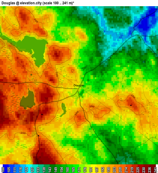
Below is the Elevation map of Douglas, which displays elevation range with different colors. Scale of the first map is from 100 to 241 m (328 to 791 ft) with average elevation of 179.4 meters (=589 ft) [note 1]
These maps also provides idea of topography and contour of this city, they are displayed at different zoom levels. More info about maps, scale and edge coordinates you can find below images.
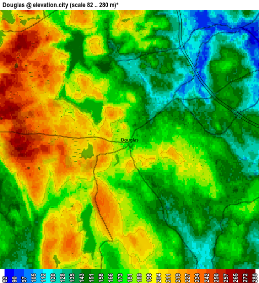
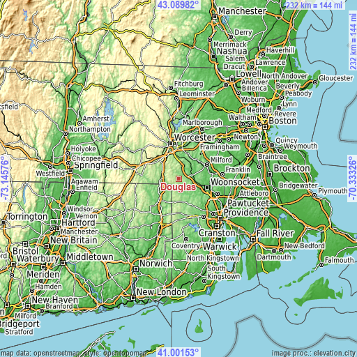
| \ | Map #1 | Map #2 | Topo.Map |
| Scale [m] | 100..241 m | 82..280 m | × |
| Scale [ft] | 328..791 ft | 269..919 ft | × |
| Average | 179.4 m = 589 ft | 175.9 m = 577 ft | × |
| Width | 7.26 km = 4.5 mi | 14.51 km = 9 mi | 232.2 km = 144.3 mi |
| Height | 7.26 km = 4.5 mi | 14.51 km = 9 mi | 232.2 km = 144.3 mi |
| ↑Max Latitude | 42.086881° | 42.119486° | 43.08982° |
| Latitude at center | 42.05426° | 42.05426° | 42.05426° |
| ↓Min Latitude | 42.021622° | 41.988967° | 41.00153° |
| ← Min Longitude | -71.783455° | -71.827401° | -73.14576° |
| Longitude center | -71.73951° | -71.73951° | -71.73951° |
| →Max Longitude | -71.695565° | -71.651619° | -70.33326° |
Nearby cities:
Cities around Douglas sort by population:
• Northbridge elevation 85 m
13.1 km,  34°
34°
• Uxbridge 76 m
9.4 km,  74°
74°
• Webster 144 m
11.6 km,  267°
267°
• Thompson 180 m
14.7 km,  223°
223°
• Sutton 218 m
10.8 km,  349°
349°
• Whitinsville 97 m
8.8 km,  43°
43°
• Oxford 156 m
12.5 km,  303°
303°
• Pascoag 132 m
11.4 km,  164°
164°
• Millville 72 m
13.4 km,  102°
102°
• East Douglas 127 m
2.9 km,  47°
47°
• Harrisville 101 m
11.2 km,  151°
151°
• North Grosvenor Dale 110 m
15.2 km,  239°
239°
Multilingual:
 En español:
Douglas elevación 179 m.
 En France:
Douglas élévation 179 m.


Sources and notes:
- [note 1] Map square and city borders are not equal. Map elevation data is calculated only from area inside that square.
- [src 1] Elevation data from geonames database provided with same terms of usage.
- [src 2] The elevation map of Douglas is generated using elevation data from NASA's 3 arcsec (90m) resolution SRTM data.
- [src 3] Base (background) map © OpenStreetMap contributors tiles are generated by Geofabrik and OpenTopoMap.
Copyright & License:
This Douglas Elevation Map is licensed under CC BY-SA. You may reuse any part from this page, if you give a proper credit by linking to this URL:
 More info on terms of use page.