Oxford elevation
Oxford (Indiana, Benton County), United States elevation is 228 meters and Oxford elevation in feet is 748 ft above sea level [src 1]. Oxford is a populated place (feature code) with elevation that is 51 meters (167 ft) smaller than average city elevation in United States.
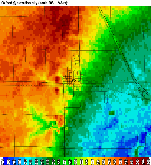
Below is the Elevation map of Oxford, which displays elevation range with different colors. Scale of the first map is from 203 to 246 m (666 to 807 ft) with average elevation of 225.2 meters (=739 ft) [note 1]
These maps also provides idea of topography and contour of this city, they are displayed at different zoom levels. More info about maps, scale and edge coordinates you can find below images.
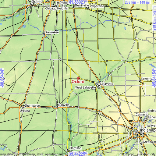
| \ | Map #1 | Topo.Map |
| Scale [m] | 203..246 m | × |
| Scale [ft] | 666..807 ft | × |
| Average | 225.2 m = 739 ft | × |
| Width | 7.43 km = 4.6 mi | 237.7 km = 147.7 mi |
| Height | 7.43 km = 4.6 mi | 237.7 km = 147.7 mi |
| ↑Max Latitude | 40.553158° | 41.58023° |
| Latitude at center | 40.51976° | 40.51976° |
| ↓Min Latitude | 40.486345° | 39.44225° |
| ← Min Longitude | -87.291735° | -88.65404° |
| Longitude center | -87.24779° | -87.24779° |
| →Max Longitude | -87.203845° | -85.84154° |
Nearby cities:
Cities around Oxford sort by population:
• Lafayette elevation 215 m
33.5 km,  109°
109°
• West Lafayette 189 m
30.6 km, 109°
• Attica 167 m
25.1 km,  180°
180°
• Fowler 254 m
12.4 km,  330°
330°
• Williamsport 195 m
26 km,  188°
188°
• Shadeland 196 m
30.1 km,  122°
122°
• Kentland 211 m
32.5 km, 329°
• Brookston 209 m
33.4 km,  73°
73°
• Battle Ground 181 m
34.4 km,  92°
92°
• Otterbein 216 m
13.2 km,  104°
104°
• Remington 226 m
28 km,  16°
16°
• Goodland 222 m
27.4 km,  351°
351°
Multilingual:
 En español:
Oxford elevación 228 m.
 En France:
Oxford élévation 228 m.


Sources and notes:
- [note 1] Map square and city borders are not equal. Map elevation data is calculated only from area inside that square.
- [src 1] Elevation data from geonames database provided with same terms of usage.
- [src 2] The elevation map of Oxford is generated using elevation data from NASA's 3 arcsec (90m) resolution SRTM data.
- [src 3] Base (background) map © OpenStreetMap contributors tiles are generated by Geofabrik and OpenTopoMap.
Copyright & License:
This Oxford Elevation Map is licensed under CC BY-SA. You may reuse any part from this page, if you give a proper credit by linking to this URL:
 More info on terms of use page.