Noblesville elevation
Noblesville (Indiana, Hamilton County), United States elevation is 236 meters and Noblesville elevation in feet is 774 ft above sea level [src 1]. Noblesville is a seat of a second-order administrative division (feature code) with elevation that is 43 meters (141 ft) smaller than average city elevation in United States.
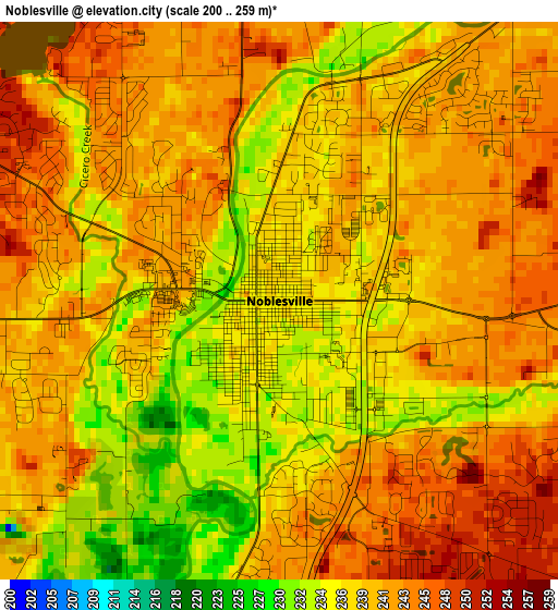
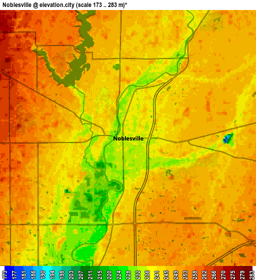
Below is the Elevation map of Noblesville, which displays elevation range with different colors. Scale of the first map is from 200 to 259 m (656 to 850 ft) with average elevation of 239.7 meters (=786 ft) [note 1]
These maps also provides idea of topography and contour of this city, they are displayed at different zoom levels. More info about maps, scale and edge coordinates you can find below images.
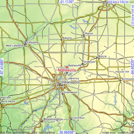
| \ | Map #1 | Map #2 | Topo.Map |
| Scale [m] | 200..259 m | 173..283 m | × |
| Scale [ft] | 656..850 ft | 568..928 ft | × |
| Average | 239.7 m = 786 ft | 246.1 m = 807 ft | × |
| Width | 7.48 km = 4.6 mi | 14.96 km = 9.3 mi | 239.4 km = 148.8 mi |
| Height | 7.48 km = 4.6 mi | 14.96 km = 9.3 mi | 239.4 km = 148.8 mi |
| ↑Max Latitude | 40.079223° | 40.11284° | 41.1136° |
| Latitude at center | 40.04559° | 40.04559° | 40.04559° |
| ↓Min Latitude | 40.01194° | 39.978274° | 38.96058° |
| ← Min Longitude | -86.052545° | -86.096491° | -87.41485° |
| Longitude center | -86.0086° | -86.0086° | -86.0086° |
| →Max Longitude | -85.964655° | -85.920709° | -84.60235° |
Nearby cities:
Cities around Noblesville sort by population:
• Carmel elevation 262 m
11.9 km,  231°
231°
• Fishers 250 m
10 km,  182°
182°
• Westfield 270 m
10.1 km,  268°
268°
• McCordsville 259 m
16.9 km,  154°
154°
• Cicero 256 m
8.7 km,  357°
357°
• Pendleton 258 m
22.9 km,  103°
103°
• Fortville 262 m
18.6 km,  132°
132°
• Sheridan 292 m
20.6 km,  298°
298°
• Ingalls 263 m
19.9 km,  119°
119°
• Lapel 261 m
13.9 km,  79°
79°
• Meridian Hills 246 m
21.4 km,  216°
216°
• Arcadia 262 m
14.5 km, 355°
Multilingual:
 En español:
Noblesville elevación 236 m.
 En France:
Noblesville élévation 236 m.
 Auf Deutsch:
Noblesville höhe über dem Meeresspiegel ist 236 m.

Sources and notes:
- [note 1] Map square and city borders are not equal. Map elevation data is calculated only from area inside that square.
- [src 1] Elevation data from geonames database provided with same terms of usage.
- [src 2] The elevation map of Noblesville is generated using elevation data from NASA's 3 arcsec (90m) resolution SRTM data.
- [src 3] Base (background) map © OpenStreetMap contributors tiles are generated by Geofabrik and OpenTopoMap.
Copyright & License:
This Noblesville Elevation Map is licensed under CC BY-SA. You may reuse any part from this page, if you give a proper credit by linking to this URL:
 More info on terms of use page.