Wasco elevation
Wasco (Illinois, Kane County), United States elevation is 253 meters and Wasco elevation in feet is 830 ft above sea level [src 1]. Wasco is a populated place (feature code) with elevation that is 26 meters (85 ft) smaller than average city elevation in United States.
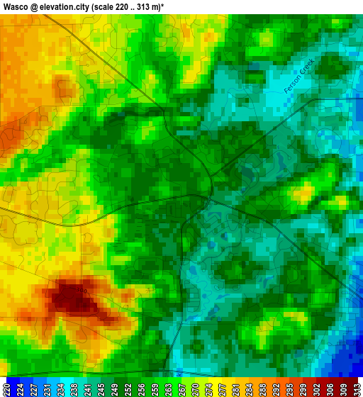
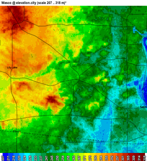
Below is the Elevation map of Wasco, which displays elevation range with different colors. Scale of the first map is from 220 to 313 m (722 to 1027 ft) with average elevation of 258.7 meters (=849 ft) [note 1]
These maps also provides idea of topography and contour of this city, they are displayed at different zoom levels. More info about maps, scale and edge coordinates you can find below images.
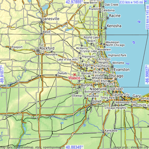
| \ | Map #1 | Map #2 | Topo.Map |
| Scale [m] | 220..313 m | 207..318 m | × |
| Scale [ft] | 722..1027 ft | 679..1043 ft | × |
| Average | 258.7 m = 849 ft | 256 m = 840 ft | × |
| Width | 7.27 km = 4.5 mi | 14.54 km = 9 mi | 232.6 km = 144.5 mi |
| Height | 7.27 km = 4.5 mi | 14.54 km = 9 mi | 232.6 km = 144.5 mi |
| ↑Max Latitude | 41.970761° | 42.003425° | 42.97555° |
| Latitude at center | 41.93808° | 41.93808° | 41.93808° |
| ↓Min Latitude | 41.905382° | 41.872668° | 40.88345° |
| ← Min Longitude | -88.448465° | -88.492411° | -89.81077° |
| Longitude center | -88.40452° | -88.40452° | -88.40452° |
| →Max Longitude | -88.360575° | -88.316629° | -86.99827° |
Nearby cities:
Cities around Wasco sort by population:
• Elgin elevation 229 m
15 km,  42°
42°
• Saint Charles 224 m
8.4 km,  108°
108°
• Batavia 219 m
12.4 km,  142°
142°
• South Elgin 219 m
11.2 km,  56°
56°
• Geneva 216 m
9.9 km,  124°
124°
• North Aurora 210 m
16 km,  156°
156°
• Village of Campton Hills 245 m
0.6 km, 105°
• Pingree Grove 280 m
14.5 km,  357°
357°
• Elburn 261 m
7.6 km,  227°
227°
• Farmington 225 m
7.4 km,  84°
84°
• Wayne 236 m
13.5 km, 83°
• Lily Lake 295 m
6.2 km,  281°
281°
Multilingual:
 En español:
Wasco elevación 253 m.
 En France:
Wasco élévation 253 m.


Sources and notes:
- [note 1] Map square and city borders are not equal. Map elevation data is calculated only from area inside that square.
- [src 1] Elevation data from geonames database provided with same terms of usage.
- [src 2] The elevation map of Wasco is generated using elevation data from NASA's 3 arcsec (90m) resolution SRTM data.
- [src 3] Base (background) map © OpenStreetMap contributors tiles are generated by Geofabrik and OpenTopoMap.
Copyright & License:
This Wasco Elevation Map is licensed under CC BY-SA. You may reuse any part from this page, if you give a proper credit by linking to this URL:
 More info on terms of use page.