Preston Heights elevation
Preston Heights (Illinois, Will County), United States elevation is 195 meters and Preston Heights elevation in feet is 640 ft above sea level [src 1]. Preston Heights is a populated place (feature code) with elevation that is 84 meters (276 ft) smaller than average city elevation in United States.
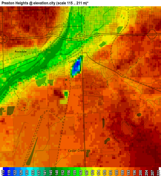
Below is the Elevation map of Preston Heights, which displays elevation range with different colors. Scale of the first map is from 115 to 211 m (377 to 692 ft) with average elevation of 186.6 meters (=612 ft) [note 1]
These maps also provides idea of topography and contour of this city, they are displayed at different zoom levels. More info about maps, scale and edge coordinates you can find below images.
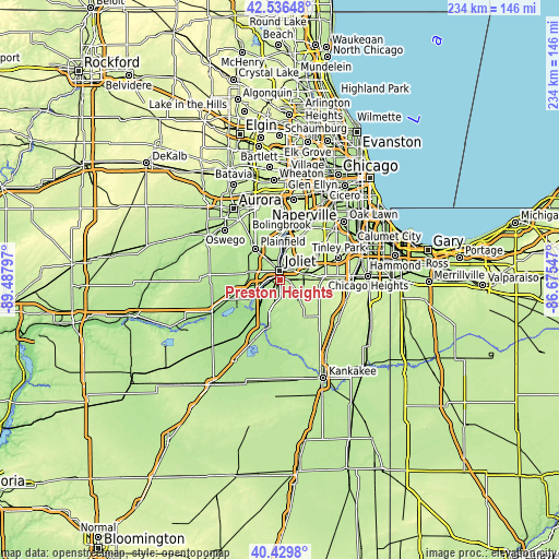
| \ | Map #1 | Topo.Map |
| Scale [m] | 115..211 m | × |
| Scale [ft] | 377..692 ft | × |
| Average | 186.6 m = 612 ft | × |
| Width | 7.32 km = 4.5 mi | 234.2 km = 145.5 mi |
| Height | 7.32 km = 4.5 mi | 234.2 km = 145.5 mi |
| ↑Max Latitude | 41.524609° | 42.53648° |
| Latitude at center | 41.4917° | 41.4917° |
| ↓Min Latitude | 41.458774° | 40.4298° |
| ← Min Longitude | -88.125665° | -89.48797° |
| Longitude center | -88.08172° | -88.08172° |
| →Max Longitude | -88.037775° | -86.67547° |
Nearby cities:
Cities around Preston Heights sort by population:
• Joliet elevation 167 m
3.7 km,  357°
357°
• New Lenox 208 m
9.9 km,  76°
76°
• Lockport 184 m
11.1 km,  10°
10°
• Crest Hill 198 m
7.2 km,  348°
348°
• Shorewood 181 m
10.5 km,  287°
287°
• Channahon 163 m
14.1 km,  240°
240°
• Manhattan 211 m
11.1 km,  133°
133°
• Ingalls Park 187 m
4.7 km,  43°
43°
• Fairmont 195 m
7.4 km, 14°
• Elwood 199 m
10.1 km,  194°
194°
• Rockdale 168 m
3.2 km,  300°
300°
• Crystal Lawns 189 m
10.8 km,  323°
323°
Multilingual:
 En español:
Preston Heights elevación 195 m.
 En France:
Preston Heights élévation 195 m.
 Auf Deutsch:
Preston Heights höhe über dem Meeresspiegel ist 195 m.

Sources and notes:
- [note 1] Map square and city borders are not equal. Map elevation data is calculated only from area inside that square.
- [src 1] Elevation data from geonames database provided with same terms of usage.
- [src 2] The elevation map of Preston Heights is generated using elevation data from NASA's 3 arcsec (90m) resolution SRTM data.
- [src 3] Base (background) map © OpenStreetMap contributors tiles are generated by Geofabrik and OpenTopoMap.
Copyright & License:
This Preston Heights Elevation Map is licensed under CC BY-SA. You may reuse any part from this page, if you give a proper credit by linking to this URL:
 More info on terms of use page.