Near South Side elevation
Near South Side (Illinois, Cook County), United States elevation is 183 meters and Near South Side elevation in feet is 600 ft above sea level [src 1]. Near South Side is a section of populated place (feature code) with elevation that is 96 meters (315 ft) smaller than average city elevation in United States.
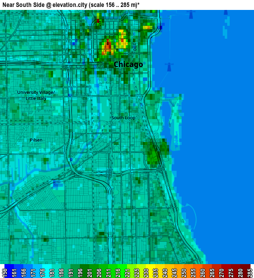
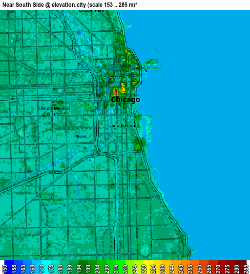
Below is the Elevation map of Near South Side, which displays elevation range with different colors. Scale of the first map is from 156 to 285 m (512 to 935 ft) with average elevation of 181.3 meters (=595 ft) [note 1]
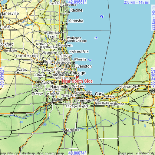
These maps also provides idea of topography and contour of this city, they are displayed at different zoom levels. More info about maps, scale and edge coordinates you can find below images.
| \ | Map #1 | Map #2 | Topo.Map |
| Scale [m] | 156..285 m | 153..285 m | × |
| Scale [ft] | 512..935 ft | 502..935 ft | × |
| Average | 181.3 m = 595 ft | 180.3 m = 592 ft | × |
| Width | 7.28 km = 4.5 mi | 14.56 km = 9 mi | 232.9 km = 144.7 mi |
| Height | 7.28 km = 4.5 mi | 14.56 km = 9 mi | 232.9 km = 144.7 mi |
| ↑Max Latitude | 41.889423° | 41.922129° | 42.89551° |
| Latitude at center | 41.8567° | 41.8567° | 41.8567° |
| ↓Min Latitude | 41.82396° | 41.791204° | 40.80074° |
| ← Min Longitude | -87.668715° | -87.712661° | -89.03102° |
| Longitude center | -87.62477° | -87.62477° | -87.62477° |
| →Max Longitude | -87.580825° | -87.536879° | -86.21852° |
Nearby cities:
Cities around Near South Side sort by population:
• Chicago elevation 180 m
2.2 km,  250°
250°
• West Town 182 m
5.9 km,  314°
314°
• Near North Side 184 m
4.9 km,  350°
350°
• New City 183 m
6.1 km,  205°
205°
• Lower West Side 183 m
3.4 km,  265°
265°
• Bridgeport 182 m
3 km,  226°
226°
• Chicago Loop 185 m
3.1 km, 346°
• Grand Boulevard 186 m
4.8 km,  172°
172°
• East Garfield Park 183 m
7 km,  292°
292°
• Douglas 185 m
2.5 km, 167°
• Kenwood 184 m
5.7 km,  156°
156°
• McKinley Park 182 m
4.9 km,  235°
235°
Multilingual:
 En español:
Near South Side elevación 183 m.
 En France:
Near South Side élévation 183 m.
 Auf Deutsch:
Near South Side höhe über dem Meeresspiegel ist 183 m.

Sources and notes:
- [note 1] Map square and city borders are not equal. Map elevation data is calculated only from area inside that square.
- [src 1] Elevation data from geonames database provided with same terms of usage.
- [src 2] The elevation map of Near South Side is generated using elevation data from NASA's 3 arcsec (90m) resolution SRTM data.
- [src 3] Base (background) map © OpenStreetMap contributors tiles are generated by Geofabrik and OpenTopoMap.
Copyright & License:
This Near South Side Elevation Map is licensed under CC BY-SA. You may reuse any part from this page, if you give a proper credit by linking to this URL:
 More info on terms of use page.