Hawthorn Woods elevation
Hawthorn Woods (Illinois, Lake County), United States elevation is 250 meters and Hawthorn Woods elevation in feet is 820 ft above sea level [src 1]. Hawthorn Woods is a populated place (feature code) with elevation that is 29 meters (95 ft) smaller than average city elevation in United States.
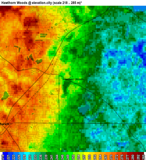
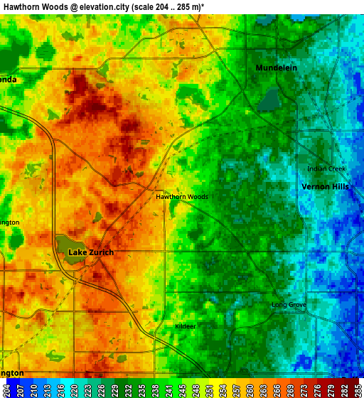
Below is the Elevation map of Hawthorn Woods, which displays elevation range with different colors. Scale of the first map is from 218 to 285 m (715 to 935 ft) with average elevation of 249.2 meters (=818 ft) [note 1]
These maps also provides idea of topography and contour of this city, they are displayed at different zoom levels. More info about maps, scale and edge coordinates you can find below images.
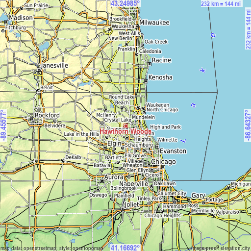
| \ | Map #1 | Map #2 | Topo.Map |
| Scale [m] | 218..285 m | 204..285 m | × |
| Scale [ft] | 715..935 ft | 669..935 ft | × |
| Average | 249.2 m = 818 ft | 243.4 m = 799 ft | × |
| Width | 7.24 km = 4.5 mi | 14.48 km = 9 mi | 231.6 km = 143.9 mi |
| Height | 7.24 km = 4.5 mi | 14.48 km = 9 mi | 231.6 km = 143.9 mi |
| ↑Max Latitude | 42.249508° | 42.282029° | 43.24985° |
| Latitude at center | 42.21697° | 42.21697° | 42.21697° |
| ↓Min Latitude | 42.184415° | 42.151844° | 41.16692° |
| ← Min Longitude | -88.093465° | -88.137411° | -89.45577° |
| Longitude center | -88.04952° | -88.04952° | -88.04952° |
| →Max Longitude | -88.005575° | -87.961629° | -86.64327° |
Nearby cities:
Cities around Hawthorn Woods sort by population:
• Mundelein elevation 226 m
6.4 km,  36°
36°
• Vernon Hills 227 m
5.8 km,  87°
87°
• Lake Zurich 268 m
4.2 km,  238°
238°
• Wauconda 246 m
8.7 km,  302°
302°
• Long Grove 225 m
6 km,  135°
135°
• Fairfield 264 m
1 km,  284°
284°
• Lake Barrington 249 m
8.5 km,  266°
266°
• Kildeer 239 m
5.2 km,  178°
178°
• Deer Park 264 m
6.8 km,  202°
202°
• North Barrington 249 m
7.6 km,  262°
262°
• Forest Lake 255 m
1.2 km,  205°
205°
• Tower Lake 243 m
8.6 km, 281°
Multilingual:
 En español:
Hawthorn Woods elevación 250 m.
 En France:
Hawthorn Woods élévation 250 m.
 Auf Deutsch:
Hawthorn Woods höhe über dem Meeresspiegel ist 250 m.

Sources and notes:
- [note 1] Map square and city borders are not equal. Map elevation data is calculated only from area inside that square.
- [src 1] Elevation data from geonames database provided with same terms of usage.
- [src 2] The elevation map of Hawthorn Woods is generated using elevation data from NASA's 3 arcsec (90m) resolution SRTM data.
- [src 3] Base (background) map © OpenStreetMap contributors tiles are generated by Geofabrik and OpenTopoMap.
Copyright & License:
This Hawthorn Woods Elevation Map is licensed under CC BY-SA. You may reuse any part from this page, if you give a proper credit by linking to this URL:
 More info on terms of use page.