Cary elevation
Cary (Illinois, McHenry County), United States elevation is 256 meters and Cary elevation in feet is 840 ft above sea level [src 1]. Cary is a populated place (feature code) with elevation that is 23 meters (75 ft) smaller than average city elevation in United States.
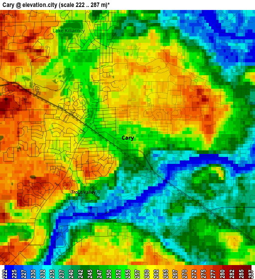
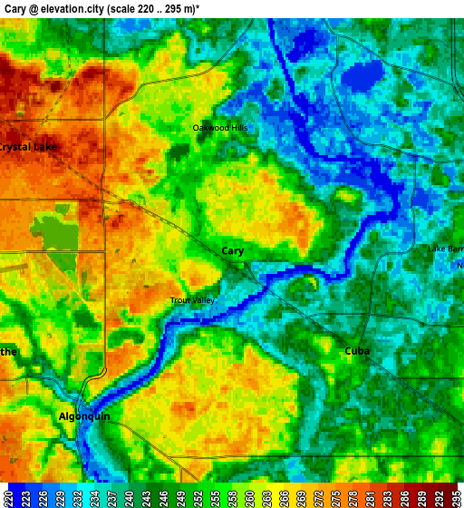
Below is the Elevation map of Cary, which displays elevation range with different colors. Scale of the first map is from 222 to 287 m (728 to 942 ft) with average elevation of 252.7 meters (=829 ft) [note 1]
These maps also provides idea of topography and contour of this city, they are displayed at different zoom levels. More info about maps, scale and edge coordinates you can find below images.
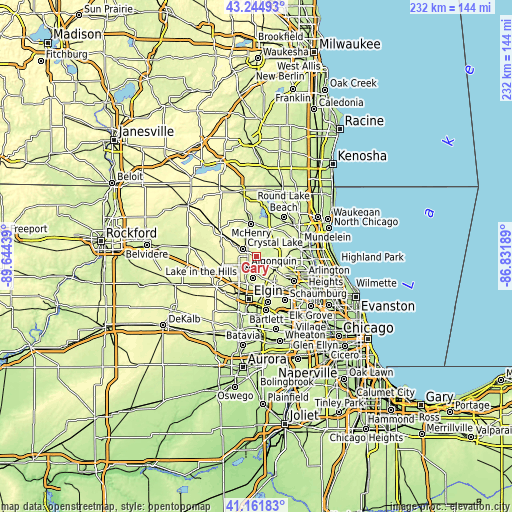
| \ | Map #1 | Map #2 | Topo.Map |
| Scale [m] | 222..287 m | 220..295 m | × |
| Scale [ft] | 728..942 ft | 722..968 ft | × |
| Average | 252.7 m = 829 ft | 251.8 m = 826 ft | × |
| Width | 7.24 km = 4.5 mi | 14.48 km = 9 mi | 231.6 km = 143.9 mi |
| Height | 7.24 km = 4.5 mi | 14.48 km = 9 mi | 231.6 km = 143.9 mi |
| ↑Max Latitude | 42.24451° | 42.277034° | 43.24493° |
| Latitude at center | 42.21197° | 42.21197° | 42.21197° |
| ↓Min Latitude | 42.179413° | 42.146839° | 41.16183° |
| ← Min Longitude | -88.282085° | -88.326031° | -89.64439° |
| Longitude center | -88.23814° | -88.23814° | -88.23814° |
| →Max Longitude | -88.194195° | -88.150249° | -86.83189° |
Nearby cities:
Cities around Cary sort by population:
• Crystal Lake elevation 277 m
7.2 km,  296°
296°
• Algonquin 227 m
6.9 km,  221°
221°
• Lake in the Hills 270 m
8.3 km,  246°
246°
• Island Lake 242 m
8.1 km,  28°
28°
• Lake Barrington 249 m
7 km,  89°
89°
• Fox River Grove 251 m
2.3 km,  122°
122°
• North Barrington 249 m
8 km, 93°
• Oakwood Hills 254 m
3.8 km,  354°
354°
• Prairie Grove 237 m
7.6 km, 345°
• Port Barrington 229 m
4.5 km,  41°
41°
• Cuba 246 m
5 km,  128°
128°
• Tower Lake 243 m
7.4 km,  72°
72°
Multilingual:
 En español:
Cary elevación 256 m.
 En France:
Cary élévation 256 m.


Sources and notes:
- [note 1] Map square and city borders are not equal. Map elevation data is calculated only from area inside that square.
- [src 1] Elevation data from geonames database provided with same terms of usage.
- [src 2] The elevation map of Cary is generated using elevation data from NASA's 3 arcsec (90m) resolution SRTM data.
- [src 3] Base (background) map © OpenStreetMap contributors tiles are generated by Geofabrik and OpenTopoMap.
Copyright & License:
This Cary Elevation Map is licensed under CC BY-SA. You may reuse any part from this page, if you give a proper credit by linking to this URL:
 More info on terms of use page.