Ashburn elevation
Ashburn (Illinois, Cook County), United States elevation is 190 meters and Ashburn elevation in feet is 623 ft above sea level [src 1]. Ashburn is a section of populated place (feature code) with elevation that is 89 meters (292 ft) smaller than average city elevation in United States.
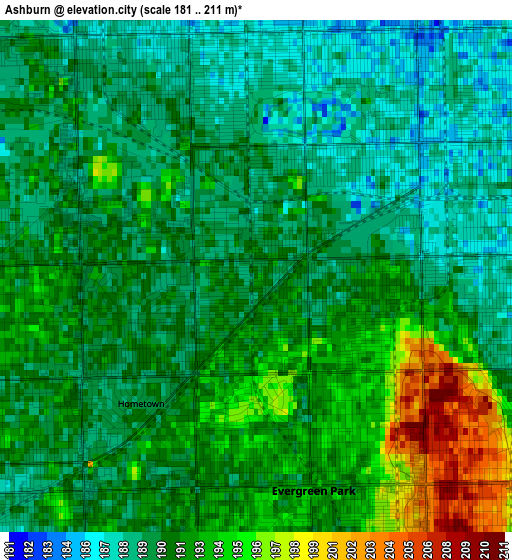
Below is the Elevation map of Ashburn, which displays elevation range with different colors. Scale of the first map is from 181 to 211 m (594 to 692 ft) with average elevation of 191 meters (=627 ft) [note 1]
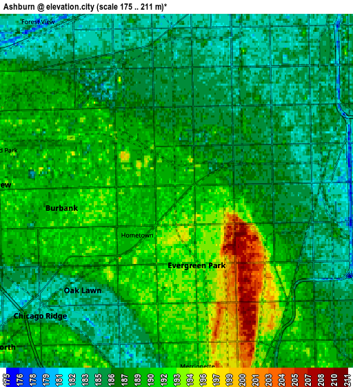
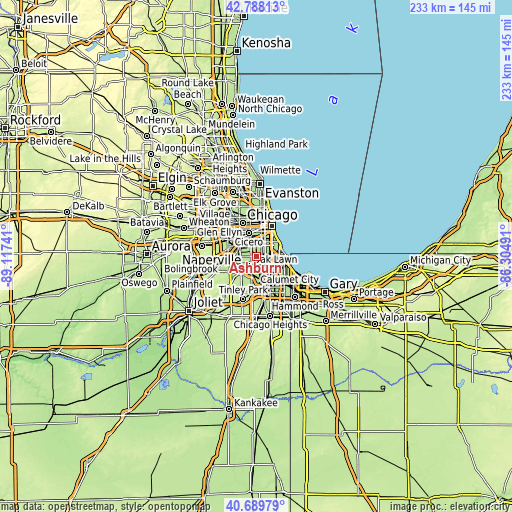
These maps also provides idea of topography and contour of this city, they are displayed at different zoom levels. More info about maps, scale and edge coordinates you can find below images.
| \ | Map #1 | Map #2 | Topo.Map |
| Scale [m] | 181..211 m | 175..211 m | × |
| Scale [ft] | 594..692 ft | 574..692 ft | × |
| Average | 191 m = 627 ft | 188.1 m = 617 ft | × |
| Width | 7.29 km = 4.5 mi | 14.58 km = 9.1 mi | 233.3 km = 145 mi |
| Height | 7.29 km = 4.5 mi | 14.58 km = 9.1 mi | 233.3 km = 145 mi |
| ↑Max Latitude | 41.780309° | 41.81307° | 42.78813° |
| Latitude at center | 41.74753° | 41.74753° | 41.74753° |
| ↓Min Latitude | 41.714735° | 41.681923° | 40.68979° |
| ← Min Longitude | -87.755105° | -87.799051° | -89.11741° |
| Longitude center | -87.71116° | -87.71116° | -87.71116° |
| →Max Longitude | -87.667215° | -87.623269° | -86.30491° |
Nearby cities:
Cities around Ashburn sort by population:
• Oak Lawn elevation 185 m
5.6 km,  223°
223°
• Chicago Lawn 188 m
3.3 km,  21°
21°
• Auburn Gresham 185 m
4.8 km,  97°
97°
• Gage Park 183 m
5.4 km,  13°
13°
• West Lawn 188 m
3 km,  341°
341°
• West Englewood 185 m
5 km,  47°
47°
• Burbank 191 m
5.9 km,  255°
255°
• Englewood 185 m
6.5 km,  56°
56°
• Evergreen Park 193 m
3.1 km,  165°
165°
• West Elsdon 184 m
5.3 km,  347°
347°
• Mount Greenwood 192 m
5.5 km,  177°
177°
• Hometown 191 m
2.2 km,  229°
229°
Multilingual:
 En español:
Ashburn elevación 190 m.
 En France:
Ashburn élévation 190 m.


Sources and notes:
- [note 1] Map square and city borders are not equal. Map elevation data is calculated only from area inside that square.
- [src 1] Elevation data from geonames database provided with same terms of usage.
- [src 2] The elevation map of Ashburn is generated using elevation data from NASA's 3 arcsec (90m) resolution SRTM data.
- [src 3] Base (background) map © OpenStreetMap contributors tiles are generated by Geofabrik and OpenTopoMap.
Copyright & License:
This Ashburn Elevation Map is licensed under CC BY-SA. You may reuse any part from this page, if you give a proper credit by linking to this URL:
 More info on terms of use page.