Eldora elevation
Eldora (Iowa, Hardin County), United States elevation is 332 meters and Eldora elevation in feet is 1089 ft above sea level [src 1]. Eldora is a seat of a second-order administrative division (feature code) with elevation that is 53 meters (174 ft) bigger than average city elevation in United States.
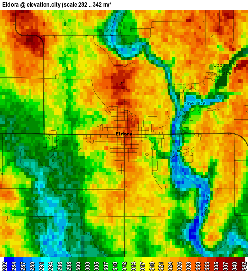
Below is the Elevation map of Eldora, which displays elevation range with different colors. Scale of the first map is from 282 to 342 m (925 to 1122 ft) with average elevation of 314.3 meters (=1031 ft) [note 1]
These maps also provides idea of topography and contour of this city, they are displayed at different zoom levels. More info about maps, scale and edge coordinates you can find below images.
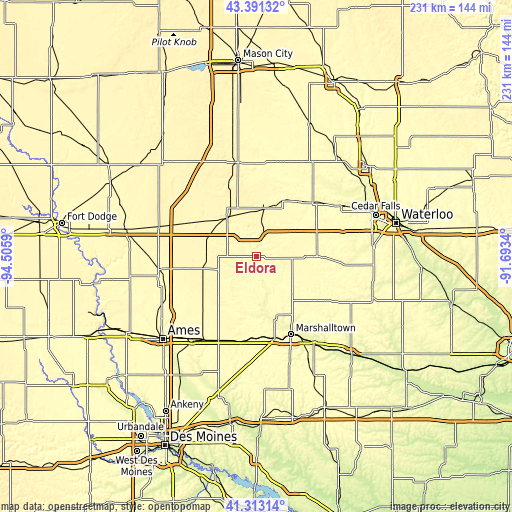
| \ | Map #1 | Topo.Map |
| Scale [m] | 282..342 m | × |
| Scale [ft] | 925..1122 ft | × |
| Average | 314.3 m = 1031 ft | × |
| Width | 7.22 km = 4.5 mi | 231.1 km = 143.6 mi |
| Height | 7.22 km = 4.5 mi | 231.1 km = 143.6 mi |
| ↑Max Latitude | 42.393284° | 43.39132° |
| Latitude at center | 42.36082° | 42.36082° |
| ↓Min Latitude | 42.32834° | 41.31314° |
| ← Min Longitude | -93.143595° | -94.5059° |
| Longitude center | -93.09965° | -93.09965° |
| →Max Longitude | -93.055705° | -91.6934° |
Nearby cities:
Cities around Eldora sort by population:
• Marshalltown elevation 289 m
38.1 km,  155°
155°
• Iowa Falls 342 m
21.9 km,  325°
325°
• Grundy Center 314 m
27.2 km,  89°
89°
• Parkersburg 300 m
35.2 km,  46°
46°
• Reinbeck 293 m
41.3 km,  95°
95°
• Ackley 335 m
21.8 km,  10°
10°
• State Center 328 m
38.6 km,  187°
187°
• Oakland 344 m
37.3 km,  310°
310°
• Roland 313 m
39.5 km,  236°
236°
• Dike 290 m
40.4 km,  73°
73°
• Conrad 308 m
23.9 km,  129°
129°
• Aplington 299 m
30.5 km,  35°
35°
Multilingual:
 En español:
Eldora elevación 332 m.
 En France:
Eldora élévation 332 m.


Sources and notes:
- [note 1] Map square and city borders are not equal. Map elevation data is calculated only from area inside that square.
- [src 1] Elevation data from geonames database provided with same terms of usage.
- [src 2] The elevation map of Eldora is generated using elevation data from NASA's 3 arcsec (90m) resolution SRTM data.
- [src 3] Base (background) map © OpenStreetMap contributors tiles are generated by Geofabrik and OpenTopoMap.
Copyright & License:
This Eldora Elevation Map is licensed under CC BY-SA. You may reuse any part from this page, if you give a proper credit by linking to this URL:
 More info on terms of use page.