Cedar Falls elevation
Cedar Falls (Iowa, Black Hawk County), United States elevation is 272 meters and Cedar Falls elevation in feet is 892 ft above sea level [src 1]. Cedar Falls is a populated place (feature code) with elevation that is 7 meters (23 ft) smaller than average city elevation in United States.
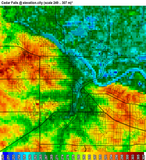
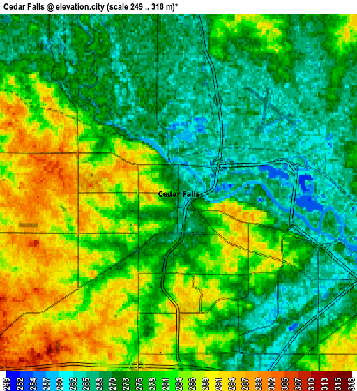
Below is the Elevation map of Cedar Falls, which displays elevation range with different colors. Scale of the first map is from 249 to 307 m (817 to 1007 ft) with average elevation of 276 meters (=906 ft) [note 1]
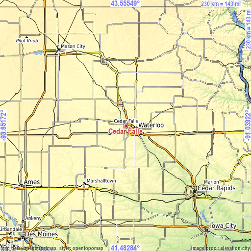
These maps also provides idea of topography and contour of this city, they are displayed at different zoom levels. More info about maps, scale and edge coordinates you can find below images.
| \ | Map #1 | Map #2 | Topo.Map |
| Scale [m] | 249..307 m | 249..318 m | × |
| Scale [ft] | 817..1007 ft | 817..1043 ft | × |
| Average | 276 m = 906 ft | 277.6 m = 911 ft | × |
| Width | 7.2 km = 4.5 mi | 14.4 km = 8.9 mi | 230.5 km = 143.2 mi |
| Height | 7.2 km = 4.5 mi | 14.4 km = 8.9 mi | 230.4 km = 143.2 mi |
| ↑Max Latitude | 42.560137° | 42.592497° | 43.55549° |
| Latitude at center | 42.52776° | 42.52776° | 42.52776° |
| ↓Min Latitude | 42.495366° | 42.462955° | 41.48284° |
| ← Min Longitude | -92.489415° | -92.533361° | -93.85172° |
| Longitude center | -92.44547° | -92.44547° | -92.44547° |
| →Max Longitude | -92.401525° | -92.357579° | -91.03922° |
Nearby cities:
Cities around Cedar Falls sort by population:
• Waterloo elevation 263 m
9.3 km,  114°
114°
• Waverly 281 m
22.2 km,  353°
353°
• Evansdale 260 m
15 km,  115°
115°
• Jesup 299 m
31.8 km,  100°
100°
• Hudson 275 m
13.5 km,  183°
183°
• La Porte City 253 m
31.5 km,  138°
138°
• Parkersburg 300 m
28.5 km,  281°
281°
• Denver 286 m
18.3 km,  28°
28°
• Reinbeck 293 m
26 km,  209°
209°
• Shell Rock 282 m
23.2 km,  330°
330°
• Dike 290 m
16.6 km,  244°
244°
• Elk Run Heights 260 m
16.9 km, 113°
Multilingual:
 En español:
Cedar Falls elevación 272 m.
 En France:
Cedar Falls élévation 272 m.
 Auf Deutsch:
Cedar Falls höhe über dem Meeresspiegel ist 272 m.

Sources and notes:
- [note 1] Map square and city borders are not equal. Map elevation data is calculated only from area inside that square.
- [src 1] Elevation data from geonames database provided with same terms of usage.
- [src 2] The elevation map of Cedar Falls is generated using elevation data from NASA's 3 arcsec (90m) resolution SRTM data.
- [src 3] Base (background) map © OpenStreetMap contributors tiles are generated by Geofabrik and OpenTopoMap.
Copyright & License:
This Cedar Falls Elevation Map is licensed under CC BY-SA. You may reuse any part from this page, if you give a proper credit by linking to this URL:
 More info on terms of use page.