Ankeny elevation
Ankeny (Iowa, Polk County), United States elevation is 300 meters and Ankeny elevation in feet is 984 ft above sea level [src 1]. Ankeny is a populated place (feature code) with elevation that is 21 meters (69 ft) bigger than average city elevation in United States.
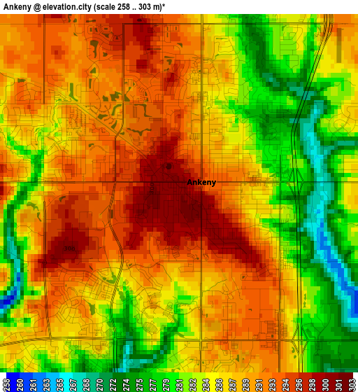
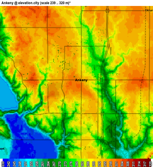
Below is the Elevation map of Ankeny, which displays elevation range with different colors. Scale of the first map is from 258 to 303 m (846 to 994 ft) with average elevation of 286.9 meters (=941 ft) [note 1]
These maps also provides idea of topography and contour of this city, they are displayed at different zoom levels. More info about maps, scale and edge coordinates you can find below images.
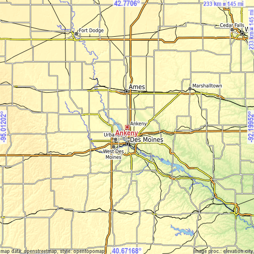
| \ | Map #1 | Map #2 | Topo.Map |
| Scale [m] | 258..303 m | 239..320 m | × |
| Scale [ft] | 846..994 ft | 784..1050 ft | × |
| Average | 286.9 m = 941 ft | 282.8 m = 928 ft | × |
| Width | 7.29 km = 4.5 mi | 14.59 km = 9.1 mi | 233.4 km = 145 mi |
| Height | 7.29 km = 4.5 mi | 14.59 km = 9.1 mi | 233.4 km = 145 mi |
| ↑Max Latitude | 41.762498° | 41.795269° | 42.7706° |
| Latitude at center | 41.72971° | 41.72971° | 41.72971° |
| ↓Min Latitude | 41.696906° | 41.664084° | 40.67168° |
| ← Min Longitude | -93.649715° | -93.693661° | -95.01202° |
| Longitude center | -93.60577° | -93.60577° | -93.60577° |
| →Max Longitude | -93.561825° | -93.517879° | -92.19952° |
Nearby cities:
Cities around Ankeny sort by population:
• Des Moines elevation 264 m
14.4 km,  181°
181°
• Urbandale 287 m
14.5 km,  217°
217°
• Johnston 251 m
9.9 km,  230°
230°
• Altoona 288 m
15.1 km,  129°
129°
• Clive 252 m
17.2 km,  214°
214°
• Grimes 289 m
16.1 km,  253°
253°
• Pleasant Hill 255 m
17.7 km,  156°
156°
• Bondurant 294 m
12.4 km,  105°
105°
• Windsor Heights 259 m
17 km, 210°
• Polk City 267 m
10 km,  297°
297°
• Saylorville 265 m
6 km,  199°
199°
• Slater 312 m
17.5 km,  339°
339°
Multilingual:
 En español:
Ankeny elevación 300 m.
 En France:
Ankeny élévation 300 m.


Sources and notes:
- [note 1] Map square and city borders are not equal. Map elevation data is calculated only from area inside that square.
- [src 1] Elevation data from geonames database provided with same terms of usage.
- [src 2] The elevation map of Ankeny is generated using elevation data from NASA's 3 arcsec (90m) resolution SRTM data.
- [src 3] Base (background) map © OpenStreetMap contributors tiles are generated by Geofabrik and OpenTopoMap.
Copyright & License:
This Ankeny Elevation Map is licensed under CC BY-SA. You may reuse any part from this page, if you give a proper credit by linking to this URL:
 More info on terms of use page.